Showing posts with label Lanikai pill box trail. Show all posts

Saturday, September 23, 2017

Hike of the rising sun: The Lanikai Pillbox trail

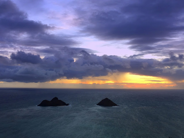
Panoramic view of the Mokuluas 
The Lanikai Pillbox Trail, also known as the Kaiwa Ridge Trail, is a family-friendly, moderate intensity, dirt and gravel hike situated in the beautiful neighborhood of Lanikai, Oahu. The top of the Kaiwa Ridge is the best place to watch the sunrise on the island of Oahu.

You must start very early, in pitch dark to reach the first pillbox before the sun pops up from behind the the Mokuluas islands and paint the sky in rainbow colors. They are collectively known as Na Mokulua (“two islands”), they’re Oahu’s most popular offshore islets and protected seabird sanctuaries. People often plan kayaking trip to the Mokuluas. From the top of the trail, you get a 360 degree view of Lanikai,Kailua and Kaneohe.  Buy Kayaks and Kayak accessories 

The two islands have been photographed and printed so many times that they have become symbol for Kailua.

We live in South Oahu, so started at 4.30 AM, zipped the Pali Hwy and were in Kailua beach parking lot by 5 AM.

There is no separate parking area designated for this trail, and you have to find a spot in the neighborhood. It’s being a residential area; many cars have received parking tickets. We thought it’s best to park at the Kailua beach park and walk the way to the start of trailhead.

 The trailhead is located between two fences on the Kaelepulu Drive, directly across from the Mid-Pacific Country Club parking lot. The start of the hike is clearly marked with signs. As soon as you enter the narrow path between the two fences, the hike ramps up very quickly. Fortunately, some good Samaritans have tied ropes to tree trunks which helps it easy to navigate the steep, dirt ascent. 

The beginning of the trailhead

The private properties on side of the trial head 

Mid Pacific Country Club 
There is no well-defined trail and it’s easy to get off the track, but because of so many people taking the trail, signs of trampled grass and well walked path can be seen. The time of sunrise changes according to the season so check before you start the hike. Keep at least 30-40 minutes at hand to reach the first pillbox before the sunrise time.

The dawn breaks 

The dawn breaks 

The pillboxes are military observation stations built during WWII, but military historian John Bennett, says, “Technically, they’re not even pillboxes. They acquired that name somewhere along the line.” A pillbox is a defensive station in which a machine gun would have been installed, he explains. These were observation stations “that were equipped with telescopic instruments.” The two stations were built in early 1943 and cost approximately $8,000 to build ($112,000 when adjusted in today’s dollars).

The first pillbox

The graffiti on the pillbox

The graffiti on the pillbox

Kailua through pillbox

rungs to go down the pillbox


The second pillbox is not very far from the first, but located at slightly higher altitude. The total elevation gained here is nearly 600 feet. Hikers climb atop each of them to get a panoramic view of rising sun along with crystal clear Lanikai waters.

In the distance, you can also see Kaneohe Bay, Chinaman’s Hat, Waimanalo Bay, and the Makapu’u Lighthouse.

You can complete the trail at the second pillbox or decide to continue further along the ridge. If you decide to complete the loop than the trail will lead you further along the coast and finally take you back to the residential houses located on A’alapapa Street.  From here you will need to walk back approximately half a mile to Ka’elepupu Drive, if you have parked the car there or to another mile to Kailua beach park.

It will take approximately an hour and half if you decide to turn back after the second pillbox. Getting down is more treacherous than climbing up and you often get off the track. It becomes more slippery if it rains during the hike. Be careful while getting down.

all set to capture the sunrise, at the first pillbox

Hikers atop the first pillbox

City of Kailua 

city of Kailua 

The second pillbox 

Sunrise

Sunrise

Capturing the sunrise atop first pillbox

The city of Kaneohe, China man's hat and Ko'olau mountain range at a distance

There are no restrooms along the hike. The closest one is located at the Kailua beach park. You will also need proper hiking shoes, lots of water, light snacks, sunscreen and hat.

Once you get down, the other attraction is the areas are Kailua Beach Park and Lanikai beach park.
Buy Lanikai Beach Wall Arts Painting and other decor

On your way to the trail, you also drive past the town of Kailua. It’s a beautiful township with lots of shopping opportunities and good food. Nearly all the local eateries like L&L barbeque, Boots & Kimo’s, Zippy’s have outlet here.

We were famished after the hike so we ate at Teddy’s bigger better burger along with Starbucks coffee.

Driving directions to the trail.


The other trail worth enjoying is Kawainui Marsh Trail. It is largest extant wetland in state of Hawaii and encompasses about 800 acres of beautiful wetlands. “Kawai” means water and “Nui” means large or abundant and refers to what really is a flood control levee at the foot of the ever-majestic Ko’olau Mountain Range.

The Golden hour 

The golden hour 

The second pillbox 

The sunrise

City of Kailua 

First Pillbox

At the trail 

The remaining ridge trail after the second pillbox 

at the top 

People atop second pillbox

waiting for the sunrise 

The Kaiwa ridge 

getting down the hike 

a flower in wild 

The country club 

people atop the first pillbox 

City of Kailua 

getting down the hike 

at the top 

the golden hour 

capturing the sunrise 

                                          Aloha Fashion


Saturday, December 19, 2015

Lanikai beach -------------The most scenic beach of Oahu

Panoramic View from Lanikai Marker


Lanikai Beach
Lanikai means”heavenly sea" in the Hawaiian language. It is postcard perfect beach with crystal azure water, fine white sand and gentle breeze that keeps the temperature cool! 

It is one of Hawaii’s best swimming beaches and frequently ranked among the world’s nicest beaches! In fact it was on number 8, among the list of top ten beaches in the world for the year 2014. And it was also ranked as US top beach in the same year!
Mokuluas Islands


It also boasts to be a popular photo spot and has lured many models and photographers over the years. No surprise considering the breathtaking scenery and surreal surroundings that the beach has to offer.
A  bride doing her photo-shoot

Once on the Lanikai beach, you see two small islands in the sea, these are twin islands of Mokuluas located offshore on Oahu’s windward coast. They are called as ‘Na Mokulua’ which in Hawaiian means The Two Islands.

Kayakers  going to Mokuluas Islands


Wind surfing at Lanikai

On any given day, schools of kayakers make the trip from either Lanikai Beach or the neighboring Kailua Beach Park, to “Mokes,” the name that the two islands are affectionately referenced to by locals.

Of the two Mokes, the northern Island i.e. the larger one is open to the public during the day, whereas the smaller or southern Island is prohibited to the public. This is because the southern strip of land in the sea is a bird reservation. So, it’s made a safe haven for all of the different and unique species of birds.


The islands can easily be reached by renting a kayak on nearby Kailua Beach and paddling about one mile (1.6 km) offshore (which takes about 45 min. to 2 hours depending on the experience of the kayaker and the ocean conditions).

Lanikai Beach is just past Kailua Beach. Take Kawailo Rd to Aalapapa Dr. Thee two major streets in Lanikai area are one way streets and form a loop. Aalapapa Dr leads into Lanikai and Mokulua Dr leads out of Lanikai. Many small streets connect these two, so it’s not difficult to navigate. Both the major streets also have bike lanes. 
Sunset over the Kailua mountains

To get to Lanikai Beach find parking along Mokulua Dr or one of its many side streets. On Mokulua Dr there are many public access points to the beach.

Lanikai Marker

Lanikai Marker: There is a stone monument built at the entrance to Lanikai at the junction of Mokulua Dr. and A'alapapa Dr.

The Lanikai Monument is a simple pillar located on a narrow strip of land that is a high point next to the road; it's there to mark the boundary and entry point of the subdivision and golf course. It is still in its original location and its original design remains almost intact.

The tapered concrete base structure is 40-feet in circumference and 56 inches high. The pillar is made of concrete and stone.

The 16 foot tall pillar has a gentle taper from its 5-foot-diameter lower portion to a slightly narrower and rounded concrete top that is capped with a conical concrete cap. Two curved metal plates near the top bear the name, "Lanikai."  (NPS)

Also known as Alala Point Coast Guard Marker, it was built in 1924 by the developers of the Lanikai housing subdivision on the rise overlooking the eastern end of Kailua Beach Park.

This spot is popular with locals and visitors alike because it sits adjacent to the Kailua Beach Park bike path and affords picturesque views of Kailua Bay, Mokapu Peninsula, and Popoi'a (Flat Island). 


View of Kailua bay from Lanikai Marker

View of Kailua bay from Lanikai Marker

NGS brass survey marker #TU1072 (N 21° 23.745 W 157° 43.221) has also been placed at the base of Lanikai Marker as a benchmark (no cache).

Many years ago, this region was a windswept plain filled with native grasses and overlooked by treeless mountains. The Hawaiians called it "Ka'ohao" which means tying or joining together. (Lanikai is a nonsensical word meaning "sea heaven" created by someone unfamiliar with the Hawaiian language.) The ancient Hawaiians used the mountain tops between Alala Point (near the stone monument at the entrance to Lanikai) and Wailea Point (near Bellows) to watch for fish.

The Hill top house

The Hilltop House:  This historical house is perched up on the hilltop overlooking Lanikai and Kailua Bay; offer 360 degree views. Built by Arthur and Anne Powlison in the 1920’s, this special home was constructed without removing or destroying any of the rocks.  Parts of the walls, floor and furniture are the rocks. “We can truthfully say that we have not chipped, chiseled, or thrown away any of the rocks…only added a bit of compatible stone” Anne Powlison, Sharing Hilltop Living 1976. For three years during WW2, the military used this home as a training center and vantage point.
Anne Powlison was affectionately known by hundreds of children as the “Bird Lady”, visiting classrooms to teach about Hawai’is bird life, in the 1960’s.  This home is now a private residence and is not open to the public for tours or visits.


Lanikai ‘Pillboxes’: One of the favorite spots for Kailuans is the view from atop Ka Iwi Ridge behind Lanikai. The short, steep hike to the “pillboxes” offers breathtaking views of the Mokulua Islands and Koolua Mountains.   While it is unclear how many were actually constructed, we do know that both the Lanikai and Diamond Head pillboxes were part of the island’s defensive system. They reportedly were observation posts built between World Wars I and II, which could alert shore artillery batteries to any approaching enemy ships. Eventually they were stripped out and left abandoned by the military.

References:
http://www.kailuachamber.com/historicallandmarks
http://www.lanikaiassociation.com/history
http://www.aloha-hawaii.com/oahu/beaches/lanikai/
http://getbustours.com/blog/lanikai-beach-a-place-that-you-wont-ever-forget/