Wednesday, May 30, 2018

What’s going on with the Kilauea Volcano?


Fissure 8 was active throughout Tuesday and into Wednesday morning sending fountains of lava at a sustained height of 200 feet with multiple secondary fountains that reached 60-feet.

This increased activity continued feeding a lava flow that moved towards Highway 132 at the rate of approximately 600 yards/hour. The flow moved north of Highway 132 in the vicinity of Noni Farms and Halekamahina roads, advancing along the steepest descent path that could take the flow to the Four Corners area.

Adding on to yesterday’s eruption, flow from fissure 18 increased further moving downslope toward Highway 137 at rates of less than 100 yards per hour. Overnight, sporadic bursts of activity were also observed from Fissures 7 and 15.

Pele's hair and other lightweight volcanic glass from high fountaining of Fissure 8 are falling to the west of the fissure and continue accumulating on the ground within Leilani Estates. Winds may waft lighter particles to greater distances. Residents are urged to minimize exposure to these volcanic particles, which can cause skin and eye irritation similar to volcanic ash.

On the other hand, Kīlauea Volcano Summit saw relatively few activities on Tuesday and into Wednesday. Ash continued to erupt intermittently from the vent within Halemaʻumaʻu crater, but vertically high ash plumes were not recorded.

USGS warns that explosive events that could produce minor amounts of ash fall downwind are possible at any time. Volcanic gas emissions at the summit remain high and will combine with wind conditions to produce widespread vog across the Island of Hawaii on Wednesday.


Kīlauea Lower East Rift Zone Fissures and Flows, May 29, 6:00 p.m. HST. Shaded purple areas indicate lava flows erupted in 1840, 1955, 1960, and 2014-2015.
Map Courtesy USGS - Hawaiian Volcano Observatory


Tuesday, May 29, 2018

Fissure 8 reactivated to create 200-feet high lava fountains


Lava eruption and gas emission continue unabated from the lower East Rift Zone (LERZ) fissure system in the area of Leilani Estates and Lanipuna Gardens. Today, fissure 8 remained very active, at times fountaining to the height of 200-feet. The lava flowed atop the Fissure 8 ʻaʻā flow that was active Sunday night/Monday morning to cross the highway 132 just before 2 pm HST Tuesday.

This voluminous activity of fissure 8 has produced Pele's hair and other lightweight volcanic glass that is being transported downwind and falling to the west of the fissure.

Tuesday also saw weak activity at fissure 18 and 19, but fissure 18 eruption has created a lava channel which has advanced 1.6 miles towards the coast.

Ash and gas eruption are continued from the summit, while ocean entry of lava has diminished significantly as viewed from this overflight photo.


Tephra (airborne lava fragments) erupted by the high lava fountains of fissure 8 was carried downwind, where the frothy rock fragments fell on Leilani Street, just past Kupono Street, in the Leilani Estates subdivision. Courtesy: USGS

Here is a video of fissure 8 reactivation


Immediate evacuation ordered as advancing lava threatens shut down of Highway 132

Lava flow near Highway 132
Fast moving lava approaching Highway 132 at Lava Tree State Park to Four Corners prompts more evacuations in Leilani estate in Puna, Big Island of Hawaii. If the Highway is completely shut down, Beach road will be the only escape route left for residents in lower Puna.

The Hawaiian Volcano Observatory reports an additional lava flow has crossed Pohoiki Road south of the Highway 132 junction.  


Late Monday afternoon, Fissure 8 erupted into volcanic fountain reaching a height of 100-150 feet, spawning a fast-moving flow that moved north along Luana Street. According to Hawaiian legend, this has led to Pele's hair being transported downwind with some strands falling in Pahoa. The United States Geological Survey (USGS) has urged the residents to minimize exposure to Pele's hair (volcanic glass), which can cause skin and eye irritation similar to volcanic ash.


Here is a YouTube video in which the Hawaii Volcanoes National Park Ranger, Adrian Boone explains the origin of "Pele's Hair" at Kilauea Volcano.


Lava Fountain at Fissure 7
Kīlauea Volcano — Fissure 7 Activity

Rapidly advancing lava consuming houses and trees

Since last reported 16, 18, 22,13, and 20 were active, with a flow moving south from Fissures 16/18.
An ash eruption at Halemaumau crater last night produced ash plume 15,000 feet in the air.  Light winds are blowing toward the northwest and ash fall may affect the Volcano and Pahala areas. Earthquakes continue in the summit region as the area is adjusting to the flow of magma.

A car being engulfed by the lava stream


Kīlauea Volcano — Pāhoehoe Flows on Kaupili Street

Here is a YouTube video by a resident as Lava surrounds his house 


Monday, May 28, 2018

Lantern Floating Ceremony on Memorial Day on Oʻahu’s south shore


 Courtesy: Nā Lei Aloha Foundation

Every year on Memorial Day, around 50,000 people gather on the south shore of Oahu in Honolulu to pay homage and tribute to veterans and honoring the loved ones who have gone before us. It an event that signifies remembrance, reflection, and offering gratitude to our family and friends who are no longer with us on this earthly journey.

The event is also live streamed and telecast to be watched by thousands around the world as 
People float special lanterns that are inscribed by hand with prayers and personal messages.

The ceremony starts with the opening of the iconic Hawaiian shell trumpet, or kani pū, followed by Japanese taiko, the ceremony then involves a chant, or oli, which calls in six large Parent Lanterns offering prayers and gratitude. And so on, this wave pattern continues.

People line up early morning at the Ala Moana beach to gather the personal lanterns that are offered free of charge on Memorial Day morning. The lantern distribution starts at 7 AM and continues till the supply lasts. You can then hand write your own special prayers and messages of remembrance on the paper provided and then float the lantern in the ceremony at sunset.


The making of lanterns
Courtesy: Nā Lei Aloha Foundation

Courtesy: Nā Lei Aloha Foundation


Courtesy: Nā Lei Aloha Foundation

If you cannot be personally present or choose not to float an individual lantern, you may place your remembrances on the original handcrafted wooden-frame Collective Remembrance Lanterns that will be floated from the canoes or from shore by volunteers.

You may visit the Shinnyo-en Hawaii temple located at 2348 S. Beretania ahead of the actual ceremony to write your remembrances on special paper that will be placed onto a Collective Remembrance Lantern.

Courtesy: Nā Lei Aloha Foundation

Collective remembrances will also be accepted at the beach on the ceremony day from 10 a.m. - 4 p.m at the Collective Remembrance Tent located next to the Lantern Request Tent.

Hawaii Convention Center provides a free parking for all those who are participating in the ceremony from 7:00 a.m.-11:59 p.m. with a complimentary shuttle and special transport for the physically disabled.

The shuttle runs from the Hawaii Convention Center to Ala Moana Beach from 3:00-6:15 p.m. and then back to the Hawaii Convention Center after the ceremony through 9:30 p.m.

May you take time to pause in remembrance and gratitude for your loved ones creating a moment of harmony and hope amid diversity.

Visit the Lantern Floating Hawaii website for more details and how to submit your messages and for information about live streaming of the ceremony.


A vigorous eruption of lava prompts more evacuation from Leilani estate


Fast moving lava flow from fissures 7 and 8 made its way into the eastern portion of Leilani Estates prompting evacuations in advance of this dangerous, rapidly moving stream of lava.

The US Geological Survey said Sunday that fissure 7 was "very active, producing a large spatter rampart over 100 feet tall from fountains reaching 150-200 feet."

One more fissure (24) has also opened on Sunday but it not actively spewing lava yet.
Ocean entry of lava continues at 3 minor points, with fissure 13 being the dominant source. Activity at fissure 22 has waned while fountaining continues at fissure 8.

Aerial view of the ocean-entry areas at about 12:30 p.m. HST. Lava flowing into the ocean diminished overnight and this morning (note lack of obvious plume at the entry areas). View is toward the northwest. Photograph courtesy of Civil Air Patrol


Pāhoehoe lava advancing west from fissure 7 (lava fountain in background) on Leilani Avenue. Fissure 7 activity increased overnight, with lava fountains reaching 50 to 60 m (164 to 197 ft) high

"Lava flow from Fissures 7 and 21 crossed into PGV property overnight and has now covered one well that was successfully plugged. That well, along with a second well 100 feet away, are stable and secured, and are being monitored. Also due to preventative measures, neither well is expected to release any hydrogen sulfide," it said.

Hawaii County Civil Defense said that lava had reached the Puna Geothermal Venture Plant, covering a well.

Volcanic gas emissions also remained very high, the USGS said. "Tradewinds are expected to diminish Sunday evening, which could expand the area impacted by vog," it said in a statement.

Since Sunday noon, no significant ash column has been produced, said USGS, "Additional explosive events that could produce minor amounts of ashfall downwind are possible at any time.”

Aerial view of Kīlauea Volcano's summit caldera and an ash plume billowing from Halema‘uma‘u, a crater within the caldera. The USGS–Hawaiian Volcano Observatory and Hawai‘i Volcanoes National Park's Jaggar Museum are visible on the caldera rim (center right); Kīlauea Military Camp can be seen in the lower right. Photo courtesy of the Civil Air Patrol.
Radar data acquired by the European Space Agency's Sentinel-1 satellite over Kīlauea Volcano shows that the summit eruptive vent continues to expand as the unsupported conduit walls collapse. The vent area is now approximately 90 acres, and the scientist at Space Agency anticipate further enlargements over the coming days to weeks as subsidence of Kīlauea caldera, rockfalls, and small explosions continue.


As of Friday, the oozing lava had destroyed 82 structures on the Big Island, of which 41 are homes Hawaii County Civil Defense Administrator Talmadge Magno said.

About 2,400 acres had been covered in lava since the Kilauea volcano eruptions began May 3, Magno said.                                      
   Kīlauea Lower East Rift Zone Fissures and Flows
Map as of 2:30 p.m. HST, May 27, 2018. Shaded purple areas indicate lava flows erupted in 1840, 1955, 1960, and 2014-2015.

Sunday, May 27, 2018

Destructive fury of Kilauea continues unabated: 270 earthquakes felt in one day


Mount Kilauea shows no sign of abatement since its started erupting lava since May 3. With 270 earthquakes recorded at the summit yesterday, here is the latest in what’s going on at Big Island of Hawaii.
The flurry of earthquakes caused four massive explosions from the volcano’s summit, sending ash clouds up to 4,500 meters into the atmosphere.

Lava from the main summit lava lake continues to seep underground into tunnels and explodes through the fissures in the ground.

According to United States Geological Survey (USGS), fissures 22, 6, and 13 are feeding lava flows moving southeast to the coast southwest of Pohoiki. At midday today, two ocean entries were active.
 Over the past 24 hours, channels feeding these ocean entries have diminished somewhat in vigor, however, the laze plume generated remains significant.

Fissure 21 is feeding an 'a'ā flow that has advanced to the northeast and this afternoon crossed Pahoa Pohoiki Road onto PGV property. Fissure 7 is feeding a flow that has turned south toward the coast, and at dusk, the lava was cascading into the Pawaii crater, adjacent to the western margin of the fissure 6 flow that feeds one of the ocean entries.

U.S. Marine Corps and National Guard helicopters are on standby for an air evacuation near Highway 130, the last exit route for coastal residents.


View of a rising ash plume from Halema‘uma‘u, a crater at the summit of Kīlauea, late yesterday

The summit area is adjusting to the withdrawal of magma and the walls of the Overlook crater are retreating. Ash continued to erupt intermittently from the Overlook crater and gas emissions also remain high. 


Friday, May 25, 2018

Some New Photos of Kilauea Eruption

This image shows the scale of the lava channels feeding the ocean entries. Note that lava is overflowing the channels and is on top of slightly older, black lava flows. The visible haze is sulfur dioxide gas that's being emitted from the fissures. Photo courtesy of J. Ozbolt, Hilo Civil Air Patrol.


Photograph of the coastline where lava flows are entering the sea. There are currently three primary ocean entry points, which have evolved over the course of the eruption. Photo courtesy of J. Ozbolt, Hilo Civil Air Patrol.

Helicopter overflight of Kīlauea Volcano's lower East Rift Zone shows the lava channel emerging from Fissure 22 (not visible but to the center, far right of the image). The lava is flowing downhill, from right to left in the photo.


HVO's webcam capture of the image of an ash plume rising from the crater


 Fissure 22 fountain is not as high as several days ago but is still erupting significant lava.


Activity at fissure 6 this morning (May 25, 2018). Lava fountains have built a small spatter cone (black mound) from which lava was spilling out onto the surface and flowing into a small pond (left of the cone).

All these photos are sourced from United States Geological Survey (USGS) or flights conducted by the Hilo Civil Air Patrol.  

Three short videos of Kilauea from helicopter overflights


Compilation of three short videos from helicopter overflights of the fissure complex, in Kīlauea Volcano's lower East Rift Zone on May 22, 2018. Fissure 22 is the dominant fissure, with lava fountaining to 50 m (about 160 ft) or more in height.

A moderate-level eruption of lava continues from multiple points along the central and northeast end of the active fissure system.

Fissure 6 through 22 are erupting lava fountains. The fountains from Fissure 22 feed a single lava channel that reaches the coast just north of MacKenzie State Park. The actual point of entry has been shifting to the west today. Spattering continues from Fissures 5, 6, and 19 that fed a lava flow to the south that is now stalled and a smaller flow to the north along and south of Pohoiki Rd. Fissures 17 continue weak spattering.

Thursday, May 24, 2018

Wednesday, May 23, 2018

The Mighty Kilauea shows no signs of slowing down

Solidified lava from Fissure 17 (located to the east of the currently active fissure complex) has a consistency similar to toothpaste.

Magma continues to be supplied to the lower East Rift Zone leading to robust eruptive activity in the middle portion of the fissure system. In the last 24 hours, the most active fissures have been 22,19, 6, 5, and 23. A faint glow was seen from Fissure 9, but no flows, and methane was observed burning in road cracks overnight.

The ocean entry remains active and is producing occasional small explosions. Observers noted the height of the perched lava pond/channel had reached 11 meters / 36 feet above the ground level.
Volcanic gas emissions remain very high from these fissure eruptions.


Blue burning flame of methane gas was observed in the cracks on Kahukai Street, during the overnight hours.


The channelized lava flow and active ocean entry. The fissure complex is visible in the upper center of the image.

Small ash emissions from the Overlook crater occurred frequently throughout the night. Moderate trade winds were blowing to the southwest and ashfall may be noticed in downwind locations. 

Earthquakes in the summit area continue at a moderate rate, as does deflation of the summit region.


Helicopter overflight of Kīlauea Volcano's lower East Rift Zone shows the lava channel emerging from Fissure 22


Hawaii’s Maunakea Observatory time-lapse sequence captures 'blue' glow from Hawaii's Kilauea volcano


A camera used at the Gemini North telescope to monitor sky conditions from Hawaii’s Maunakea captured a remarkable time-lapse sequence of the Kīlauea volcanic eruption. The sequence shows the glow from an extensive region of fissures over the course of a single night (May 21-22). During the sequence, multiple fissures expelled lava in the area in and around Leilani Estates in the Puna district of the Big Island of Hawai‘i. The lava also flowed into the ocean during the period of the video.

The camera used for the sequence looks eastward toward the town of Hilo (center), which is mostly obscured by clouds. The moon illuminates the landscape early in the sequence. Later, the setting moon (behind the camera) casts shadows of Gemini and several Maunakea observatories as well as a projection of the mountain onto the atmosphere.

The Gemini Observatory consists of twin 8.1-meter diameter optical/infrared telescopes located on two of the best observing sites on the planet. From their locations on mountains in Hawai'i and Chile, Gemini Observatory's telescopes can collectively access the entire sky.

Gemini is operated by a partnership of five countries including the United StatesCanadaBrazilArgentina, and Chile. Any astronomer in these countries can apply for time on Gemini, which is allocated in proportion to each partner's financial stake.

Video Courtesy: Gemini Observatory 


Monday, May 21, 2018

Kīlauea Volcano - Spattering (Aerial Between Fissures 16 and 20)


Aerial view (from a helicopter) of spattering between fissures 16 and 20, Kīlauea Volcano Lower East Rift Zone, at approximately 7:30 AM HST on May 16, 2018. The audio is the sound of the helicopter.

Kīlauea Volcano — Fountaining at Fissure 20

                                               Kīlauea Volcano — Fountaining at Fissure 20

Kilauea volcano lava cuts off key escape route in Hawaii, man injured


                       Kilauea volcano lava cuts off key escape route in Hawaii, man injured

Finally, the erupting and overflowing lava meets the ocean to create more health hazards


White plumes of acid and fine shards of glass fill the Hawaiian sky over the east coast of Big Island as Lava from active fissures near the Leilani Estates subdivision gushes into the Pacific Ocean at 2 points along the coastline. The lava has completed nearly 4-mile crawl to meet the ocean, creating dangerous living conditions for residents in Kamaili, Seaview, and Malama Ki neighborhoods.
It was about 11 P.M. on Saturday night when the emergency management officials first confirmed that lava from fissure 20 has reached the ocean.


Ocean entry photograph from Civil Air Patrol (CAP) overflight taken at about 12:50PM.


The 20th fissure opened on May 15, 2018, in Kilauea's eastern rift zone and has been spewing lava since then. The lava flow suddenly increased beginning Friday, May 18 when the fissure 16 and fissure 20 merged resulting in a continuous line of splatter and fountaining.

The merger happened less than a mile from the coast and created a  lava river that slowly meandered southward between Pohoiki and Opihikao Rds on its way towards the ocean. 


The lava river

Lava fountain at fissure 22, 9:03 a.m. HST


                                                         USGS Video of lava fountain 


Meanwhile, a crack has opened under the east lava channel early Sunday morning diverting the lava from the channel into underground voids. This may stall the lava flow into the ocean.

The sudden increase in the volume of lava eruption from fissure 20 has tripled the volcanic gas emissions and SO2 concentration in the area downwind of the vents.

Seismic levels which abruptly decreased after explosive eruptions on Saturday afternoon and Sunday noon, are again slowly increasing along with continued deformation at the Kilauea summit.

A small explosion occurred at 12:55 AM at Halema'uma'u crater at Kilauea's summit. It produced an ash plume that reached about 7,000 ft and was carried by the wind to the southwest.

As the flow pours into the water and creates new land, officials are issuing new warnings about the threat for laze, the steam-like substance that rises from the ocean as the lava comes into contact with ocean water. Laze is a mix of hydrochloric acid, steam, and fine glass particles.

Laze plume travels with the wind and can cause lung damage, and eye and skin irritation.

Meanwhile, The United States Geological Survey has just updated about fissure 22 putting on a show, with lava fountains as high as 150 feet in the air. 


Thursday, May 17, 2018

Explosion at the summit of Hawaii's Kilauea volcano creates a 30,000 feet tall ash plume

Webcam image shows the plume of ash from Thursday morning's explosive eruption at Kilauea (Image: USGS)

Hawaii Volcano Observatory officials confirmed that there was an explosive eruption at around 4:15 a.m., at the summit of Kilauea which created a massive volcanic cloud reaching 30,000 feet. That's a little below the cruising altitude of a jetliner.

Huge plumes of ash poured from Halemaumau Crater as volcanic activity at the summit continued. (Image: Janice Wei)

"At any time, the activity may again become more explosive, increasing the intensity of ash production and producing ballistic projectiles near the vent," the USGS said. "Ballistic projectiles may be produced should steam-driven explosions occur. Impacts will be limited to an area around Halemaumau."

image from a temporary thermal camera positioned on the northwest flank of Puʻu ʻŌʻō showing the heat map


Earlier, the ash plume rose to 12,000 feet on Tuesday, covering the surrounding areas in a thick blanket of smoke and ash.

The National Weather Service has issued an ashfall advisory after radar showed the massive plume. The wind is expected to carry the ash plume toward Ka'u, Volcano, Mountain View, Keaau and as far as Hilo.

The explosion followed a series of 125 shallow quakes that rattled Kilauea's summit and neighboring communities since 1 day.

Michelle Coombs, of the U.S. Geological Survey, said the situation remains "very, very active and very dynamic. Scientists were not surprised by the volcano explosion that sent a cloud of volcanic ash up to 30,000 feet above sea level Thursday. She said even more powerful events could follow.


Michelle Coobs with U.S. Geological Survey says scientists were not surprised by the volcano explosion that sent a cloud of volcanic ash up to 30,000 feet above sea level Thursday. She said even more powerful events could follow.

The quakes are being caused by the ongoing deflation at the summit and as lava levels continue to plummet. As of Wednesday afternoon, the floor of the Kilauea caldera has dropped about 3 feet.

Close view of rock hurled from the Overlook crater during an explosive event last evening. The rock broke apart on impact and was about 60 cm (24 in) before it hit the ground.


Also on Wednesday, Hawaiian Volcano Observatory said rocks up to 2 feet wide were hurled from the crater to a parking lot hundreds of yards away. The hurling of these ballistic rocks could reflect the onset of a steam-driven explosion that the officials are expecting since long. This will happen as the lava level continue falling and touch the water table beneath the Kilauea caldera, creating a massive explosion.

Researchers don't know when the explosive activity will occur, how large the explosions could be or how long they'd last.

Don Swanson, of the Hawaiian Volcano Observatory said, "If an explosion happens, there's a risk at all scales. If you're near the crater within a half a mile or so, then you would be subject to a bombardment by ballistic blocks weighing as much as 10 or 12 tons."

Wednesday, May 16, 2018

Hawaii Volcano Eruption Update - Wednesday Night (May 16, 2018)

Ash emission from the Overlook crater within Halema`uma`u has generally decreased since yesterday. Although varying in intensity, at times the plume contains enough ash to be gray in color. The cloud is rising an estimated 3 to 4,000 feet above the ground, but altitudes are varying with pulses of emission. The ash cloud is drifting slowly northward from the Kilauea summit and ashfall may occur in Hawai`i Volcanoes National Park and Volcano Village. Communities downwind may receive ashfall and should take necessary precautions.

Strong earthquakes within the summit of Kīlauea Volcano continue in response to ongoing deflation and lava column drop. As of the afternoon of May 16, the floor of Kīlauea caldera has dropped approximately 3 feet (90 cm). This movement is stressing faults around the caldera of Kilauea, causing them to move and resulting in strong earthquakes of up to magnitude 4.4 thus far.

Employees at the Hawaiian Volcano Observatory, Hawai`i Volcanoes National Park, and nearby residents are reporting frequent ground shaking and damage to roads and buildings. Hawaii County Police reports cracks across Highway 11 between mile markers 28 and 29. Although these are passable, motorists are urged to use caution.

As deflation continues, strong earthquakes in the area around Kilauea Volcano's summit are expected to continue and may become more frequent. Areas further from these earthquakes may feel some ground motion as well, but much less severe.


The shallow depths of these earthquakes make them more damaging in the immediate vicinity of the epicenter, and individuals need to take precautions to minimize damage from the shaking, including the removal of unstable items from walls and shelves. Steep slopes should be avoided as they may become destabilized during strong earthquakes.


U.S. Geological Survey


Paradise Shaken: Is it the wrath of Madam Pele-The Goddess of fire on the Hawaiian Islands?


Strong earthquakes, erupting and spluttering lava and toxic gas has shaken the residents of southern part of Big Island of Hawaii as magma shift underneath a restless Kilauea Volcano.

The residents of the big island Hawaii react to this natural disaster with grief and reverence. According to Hawaiian legend, the Halemaʻumaʻu crater at the summit of the Kīlauea volcano is home to the Pele-Hawaiian goddess of fire, volcanoes, and lightning and wind. Referred to as madam Pele or Tutu grandmother – Pele is regarded as the powerful force behind Kilauea's decades-long eruptions.


Goddess Pele, Image from Jaggar Museum, Hawaii

Hawaiian people believe that sometimes Pele needs to clean the land and the eruption, lava, and ash flow are all her ways of teaching people how to live on the islands.

It’s she who makes the decision that where the lava flows and how the land is shaped for future generation. It is believed that Pele is out to reclaim the land that was taken from her. At the end of the day, Pele will take what is rightfully hers.

The residents are offering Ho’okupu of Ti leaves in front of lava flow to the fire goddess to calm her down as they prepare to leave their homes in Leilani estate.

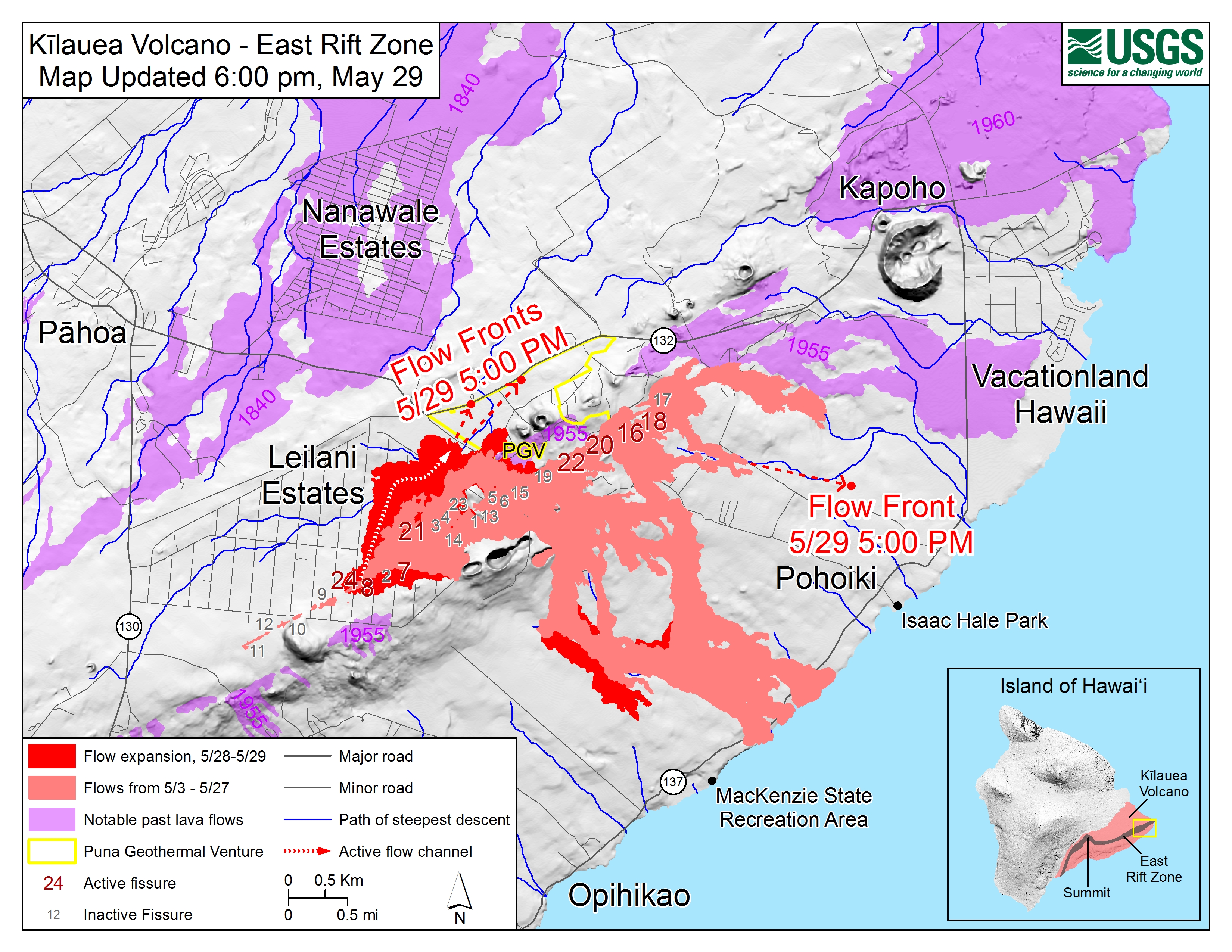
Timeline of the current eruption


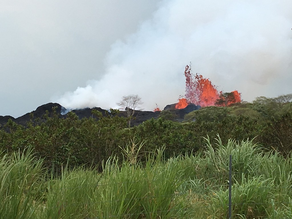
In this photo released by the U.S. Geological Survey, lava is shown burning in Leilani Estates subdivision near the town of Pahoa on Hawaii's Big Island on Thursday


Kilauea is Hawaii’s most active volcano and has been erupting continually since 1983. Hawaii officials have been warning the residents in Puna, Big Island Hawaii since Monday, April 30 that they should prepare to evacuate since an eruption can come anytime from the mighty Kilauea.  This warning came after the Puu Oo crater floor began to collapse on Monday, triggering a series of earthquakes and pushing the lava into new underground chambers towards the populated southeast coastline of the island.


A clear view into Pu‘u ‘Ō‘ō crater. The upper part of the crater has a flared geometry, which narrows to a deep circular shaft. The deepest part of the crater is about 350 m (1150 ft) below the crater rim.


According to the U.S. Geological Survey, there were nearly 70 earthquakes of magnitude 2.5 or stronger from Tuesday to Wednesday alone.

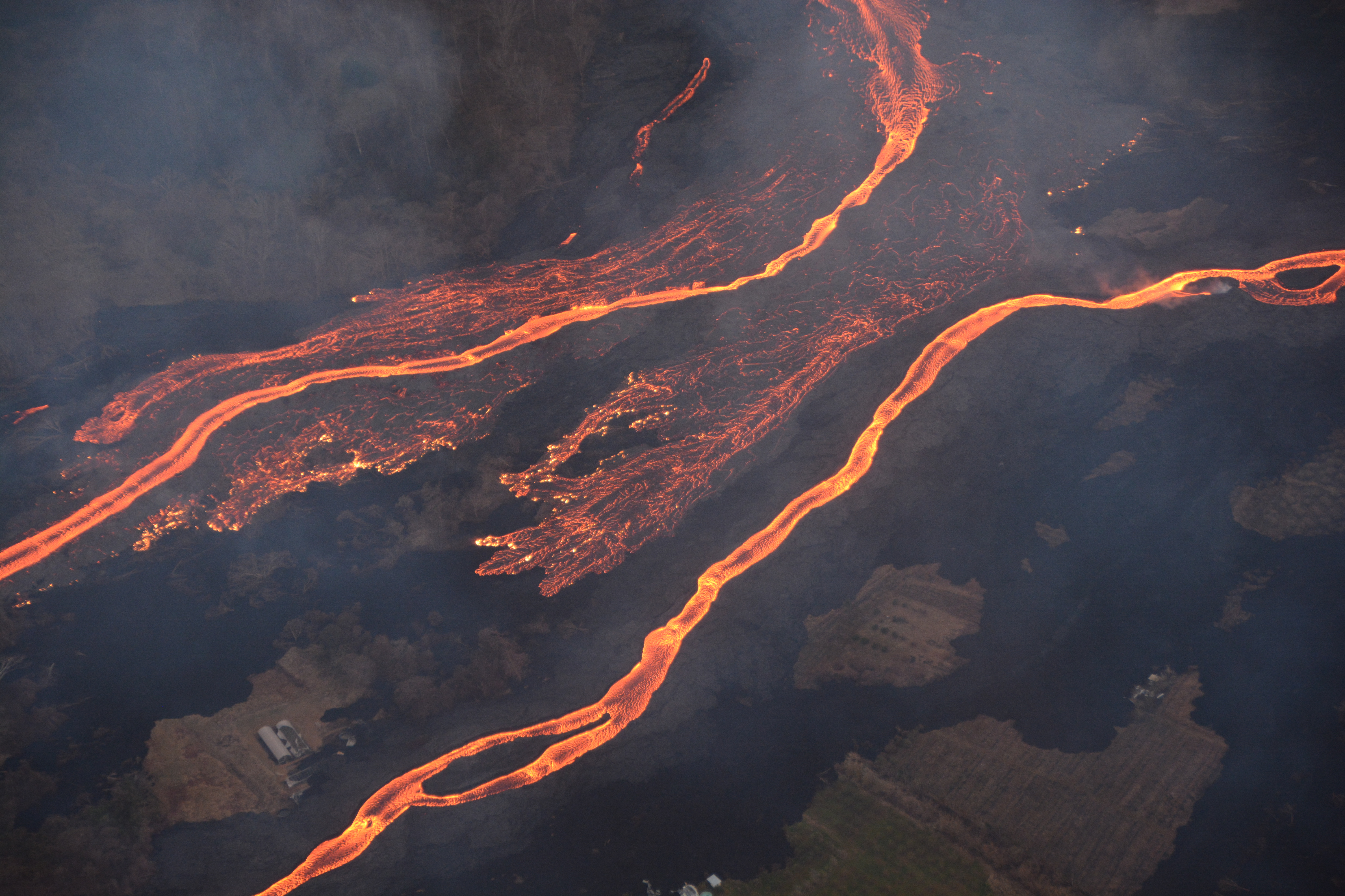
The Monday collapse caused magma to push more than 10 miles downslope toward the populated southeast coastline of the island.

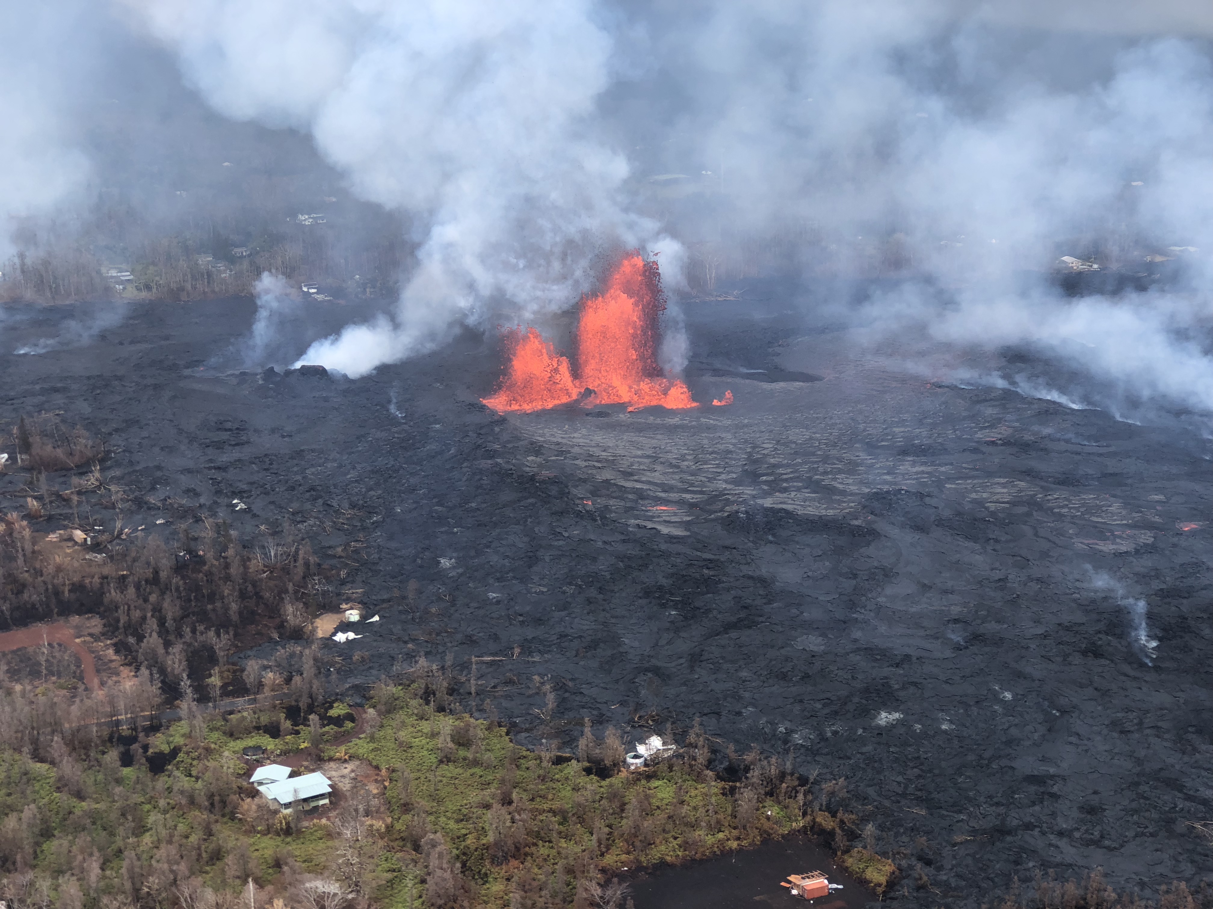
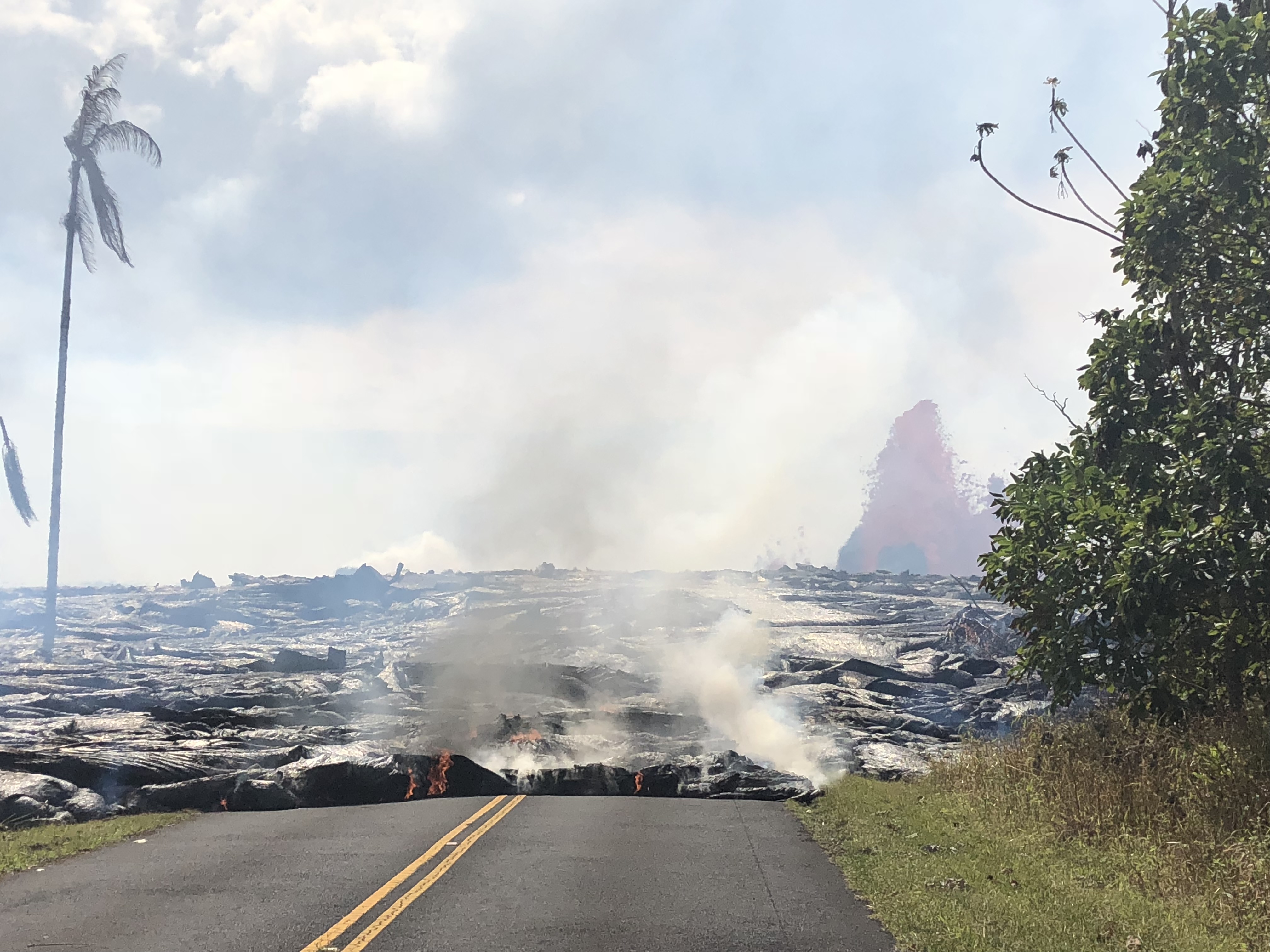
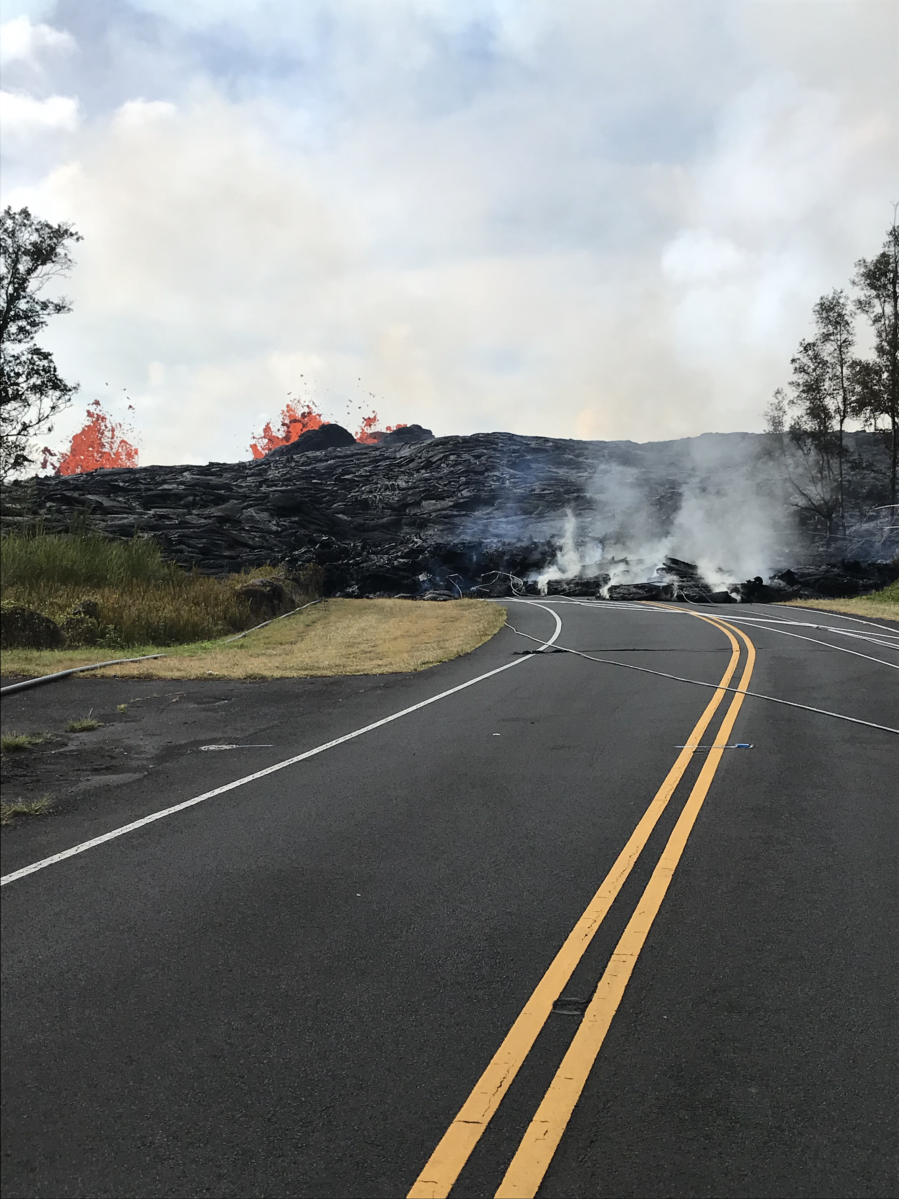
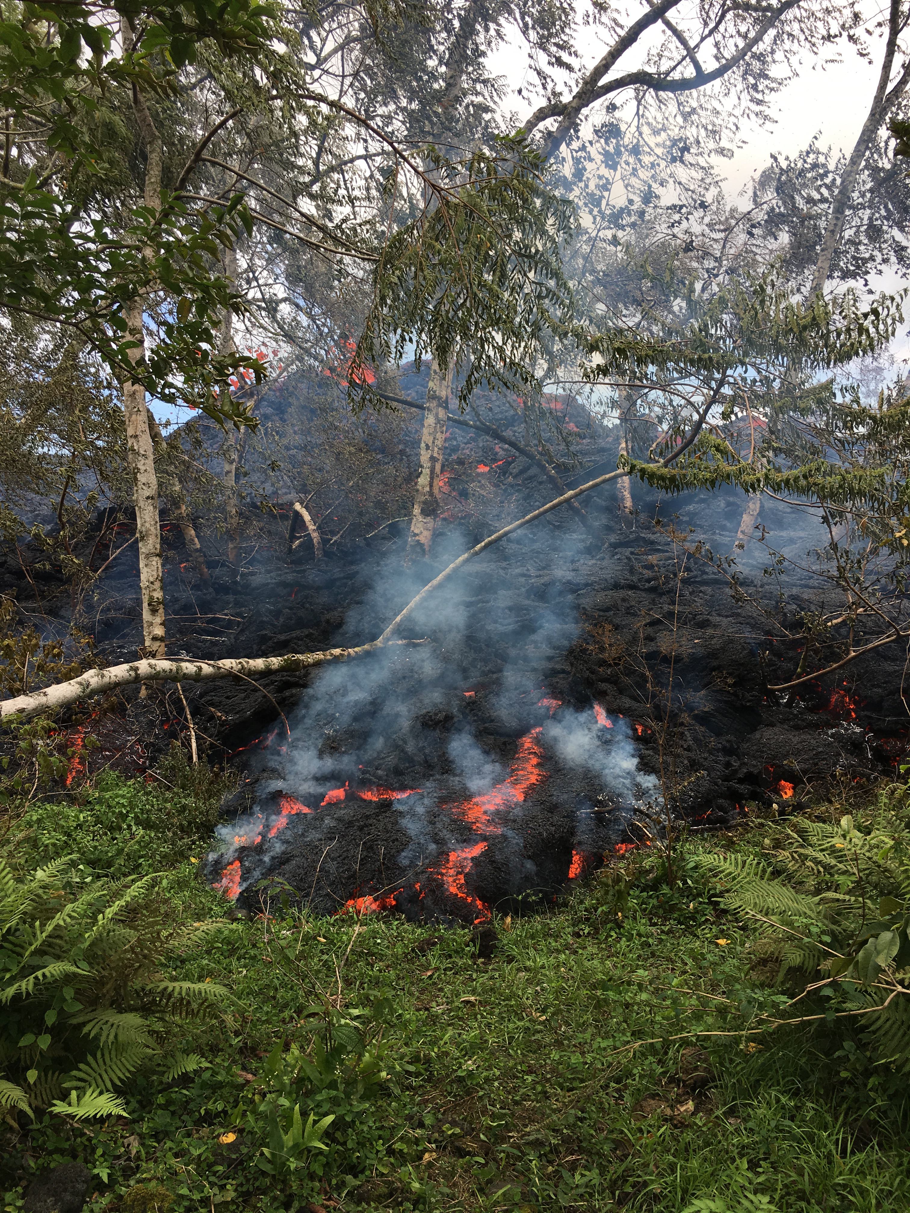
The eruption first started on Thursday, May 03, 2018 several hours after a magnitude-5.0 quake struck the Big Island. The eruption spewed lava into residential subdivisions in the Puna district of the Big Island, prompting mandatory evacuations of the Leilani Estates and Lanipuna Gardens subdivisions.

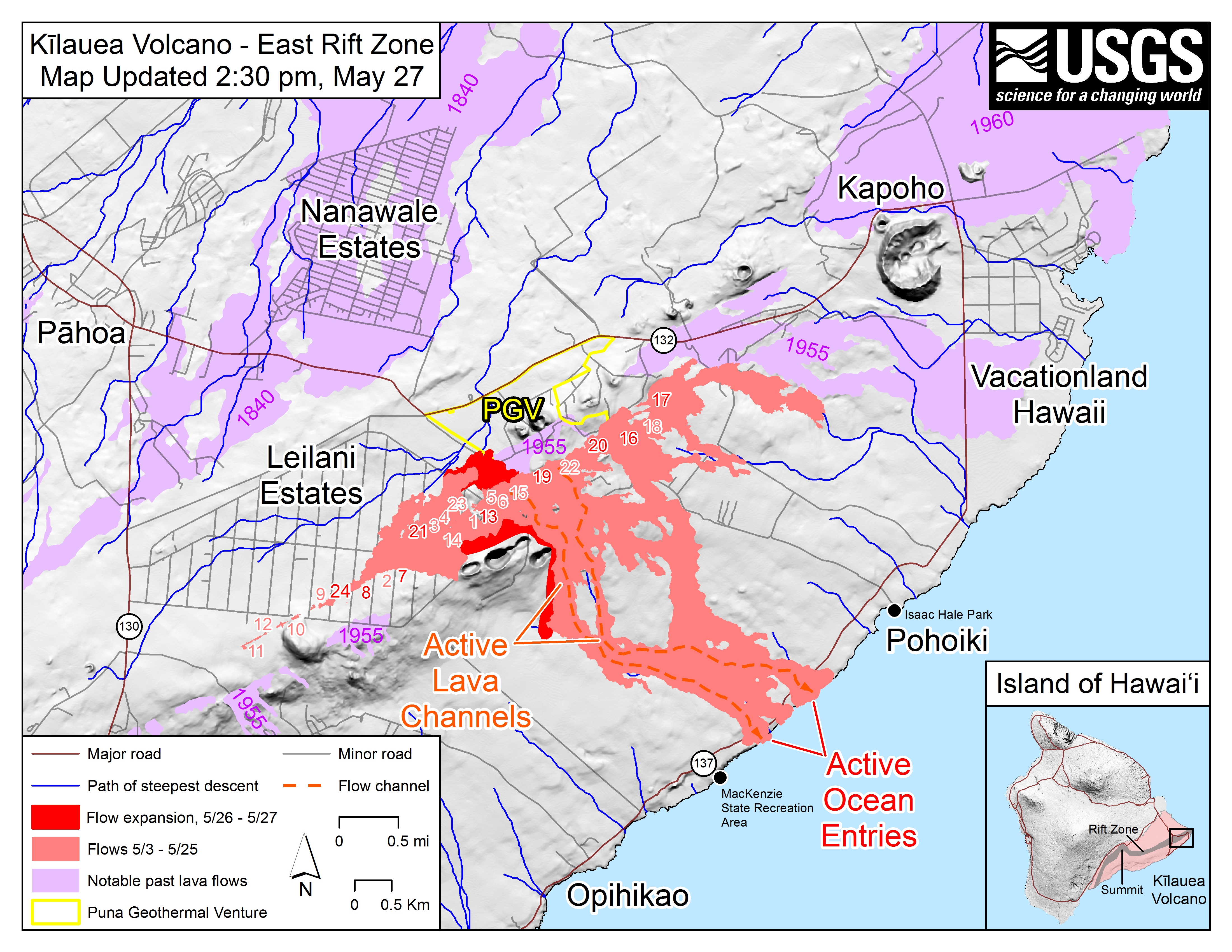
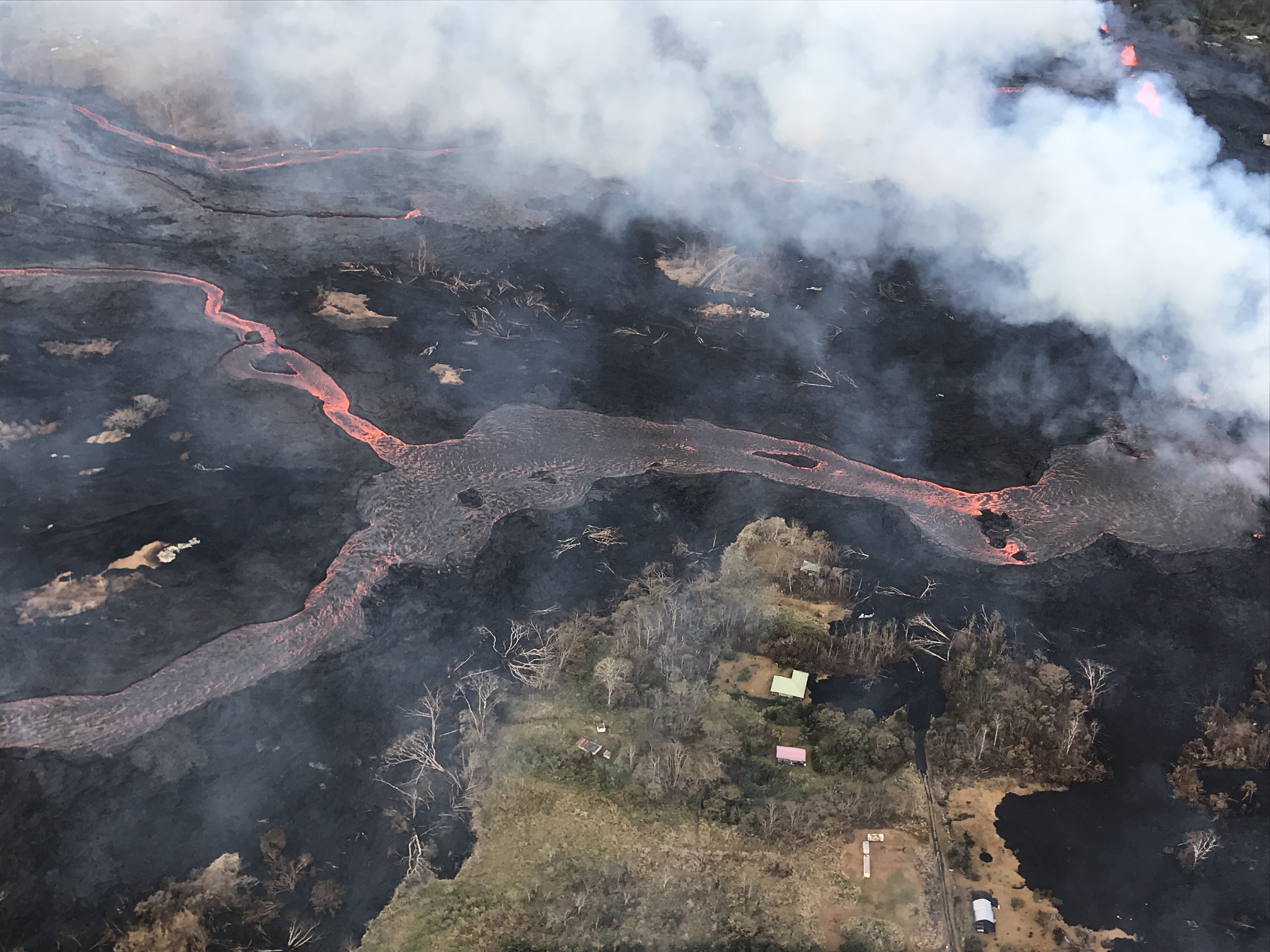
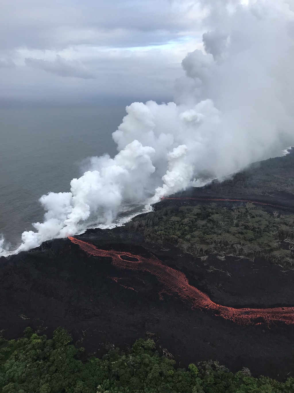
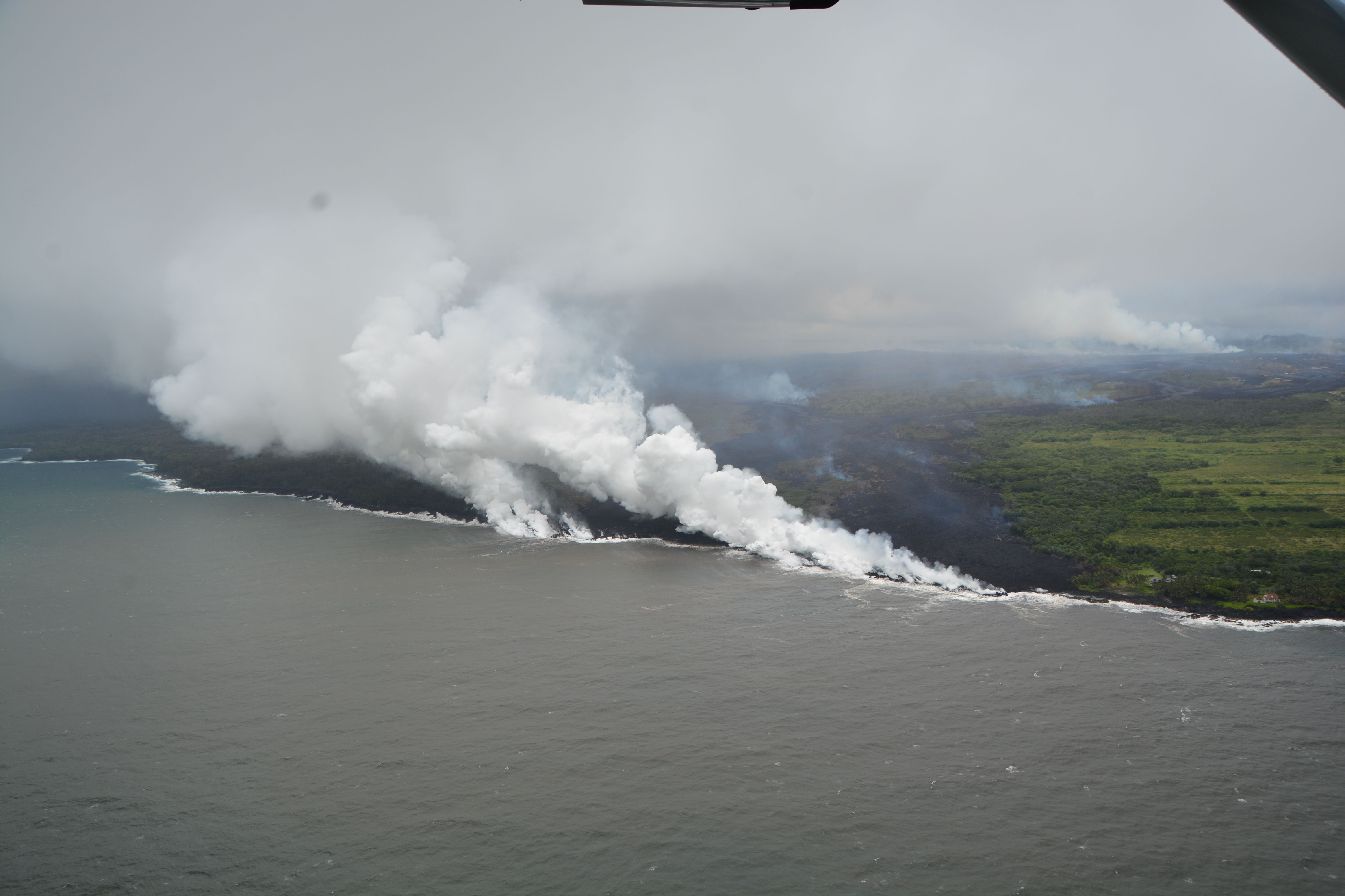
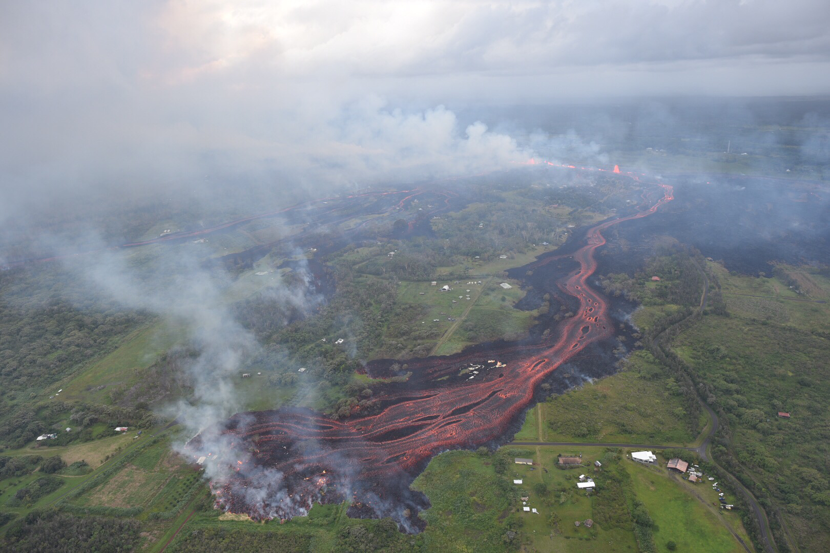
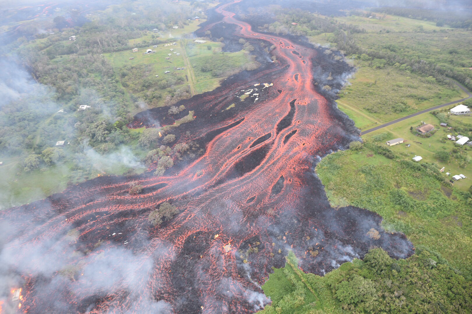
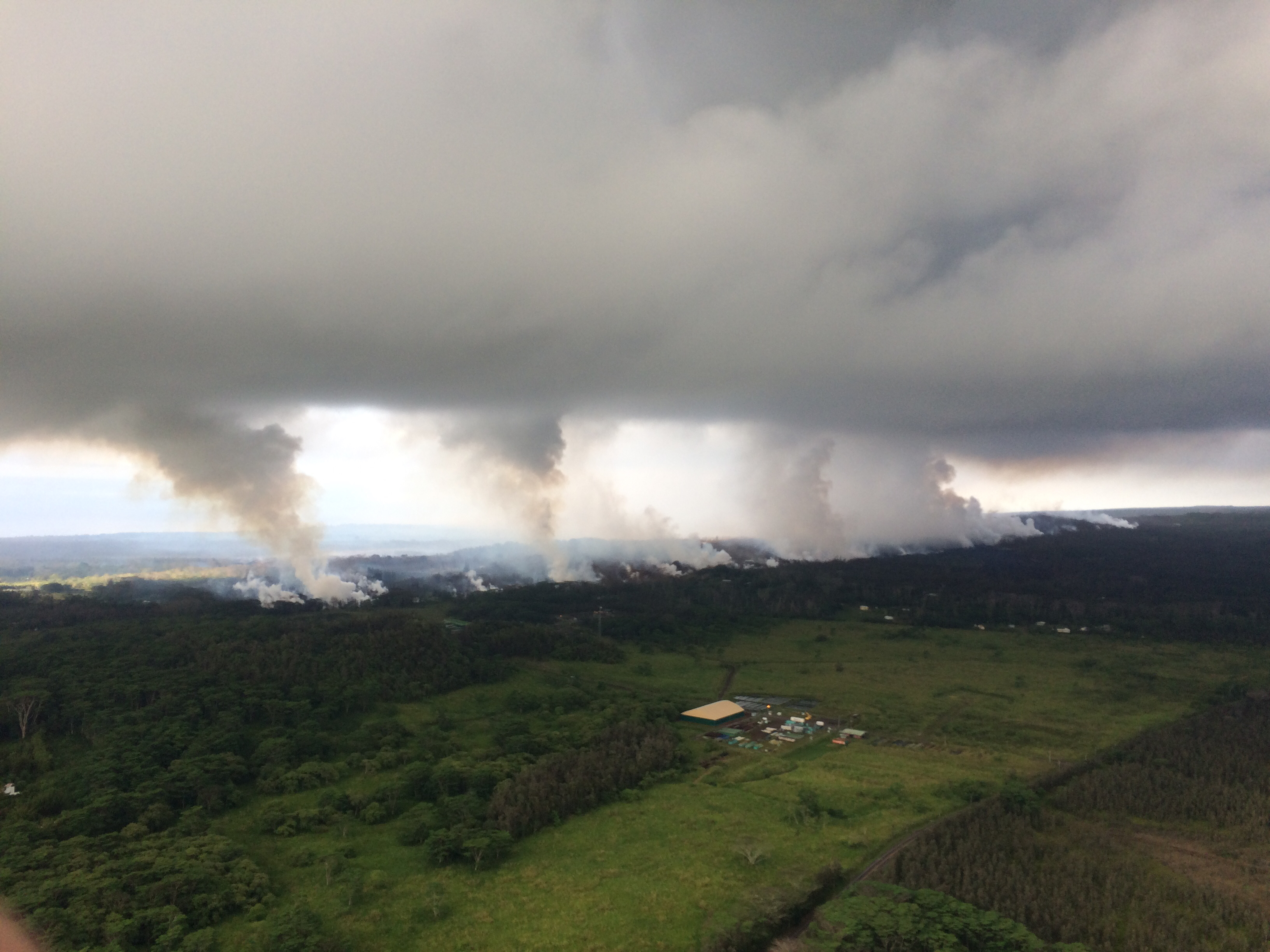
As of today, 20 fissures have opened since May 3 in Kilauea’s east rift zone, where a few small subdivisions have been built in recent years. The lava from them has shot hundreds of feet into the air, swallowed cars, destroyed about 27 homes, and forced around 2,000 residents to flee.

  • Some 37 structures have been destroyed
  • Lava has covered more than 117 acres of land in Kau and Puna district
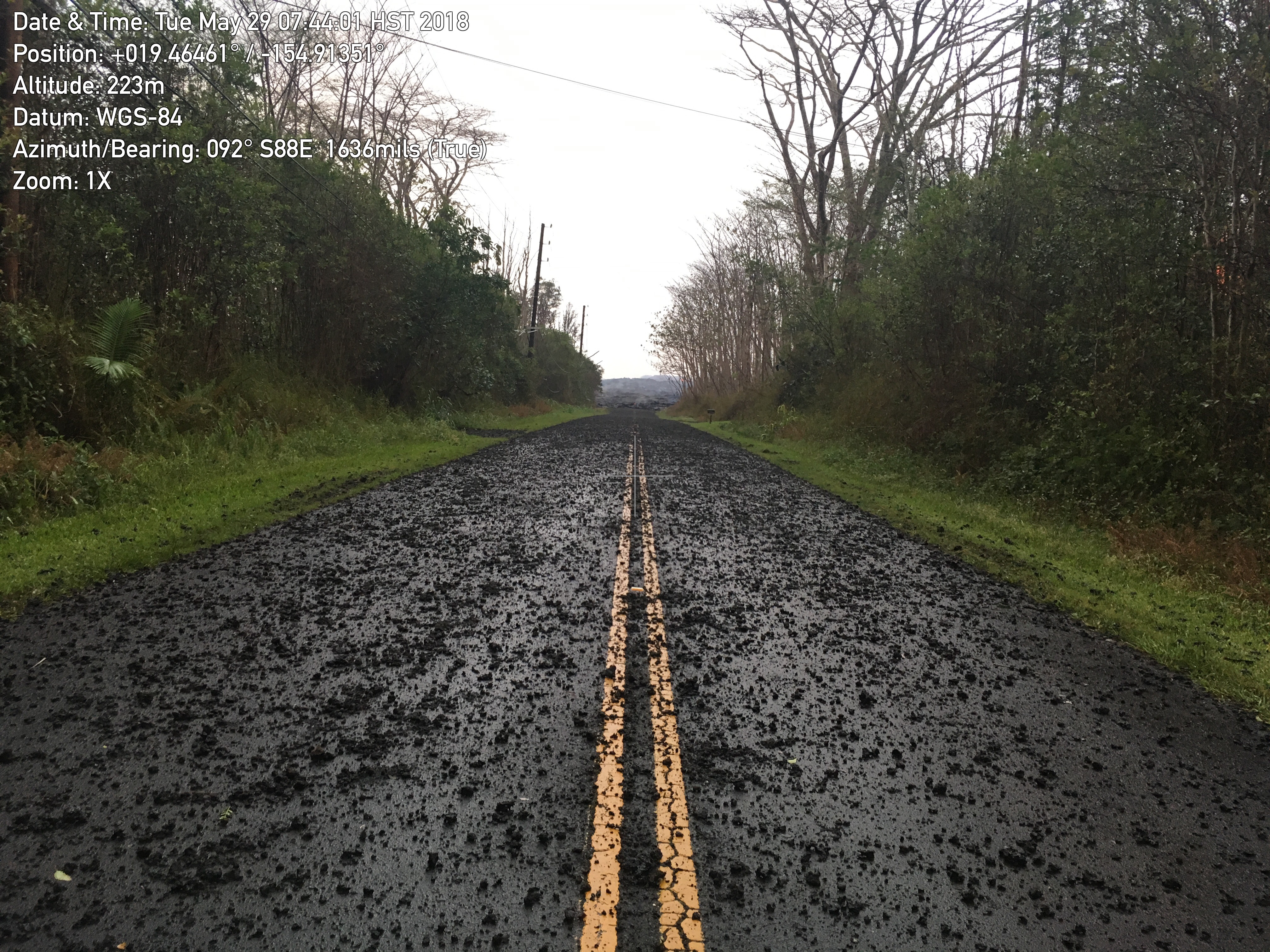
  • At least nine roads are now impassable.
  • As many as 50 utility poles have been damaged by the lava, and hundreds have been without power since the eruptions started.

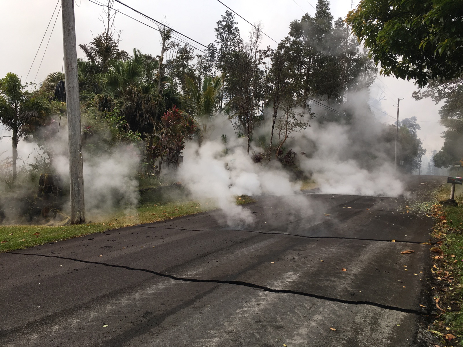
steam rising from fissure 9 on Moku Street in the Leilani Estates 

lava slowly advancing from fissure 16.

Lava spattering from an area between fissures 16 and 20

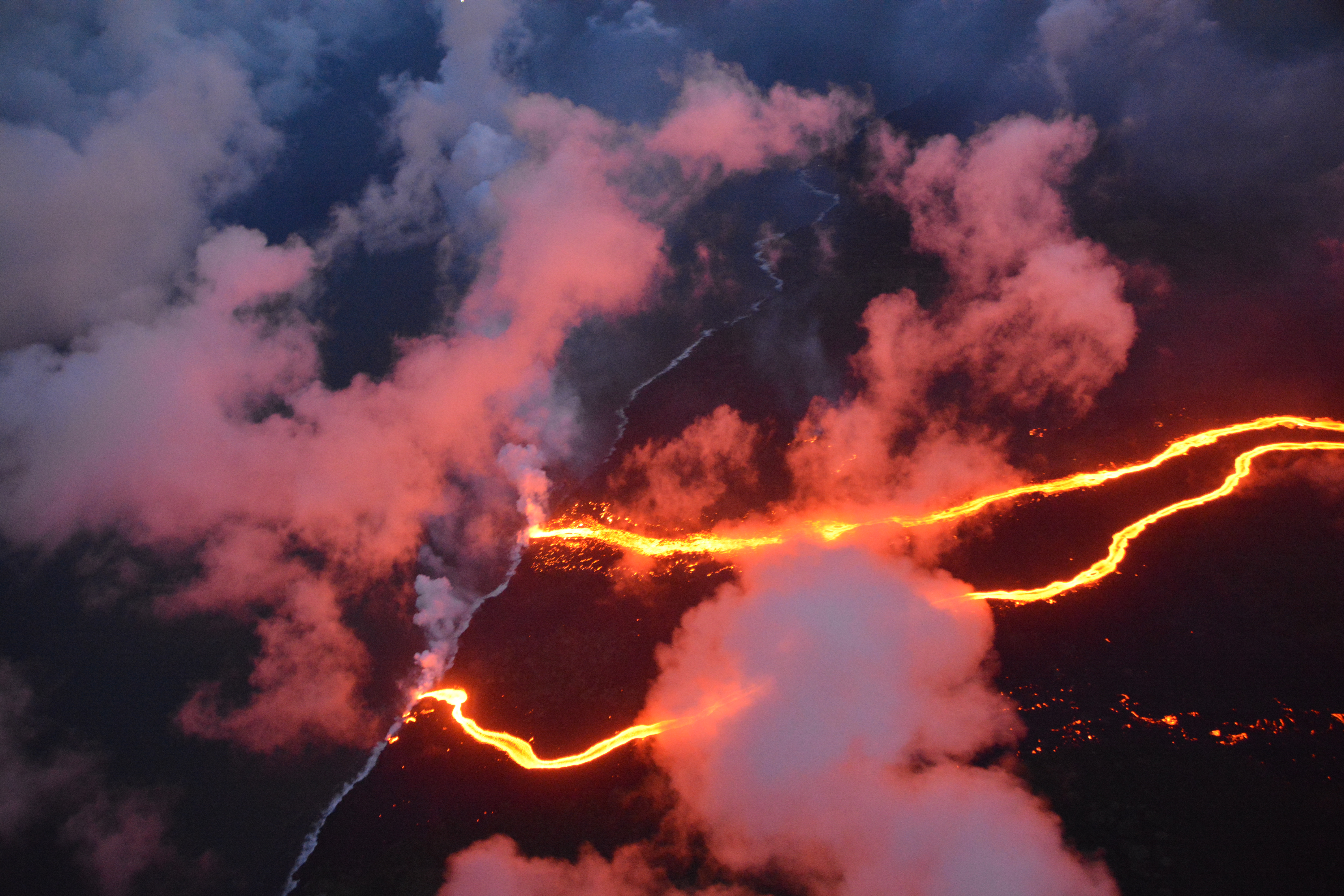
And it’s not over. The US Geological Survey (USGS) warns that “additional outbreaks of lava are likely” and that steam pressure building below the surface could cause explosions raining “ballistic projectiles and ashfall” within half a mile or more from the volcano.


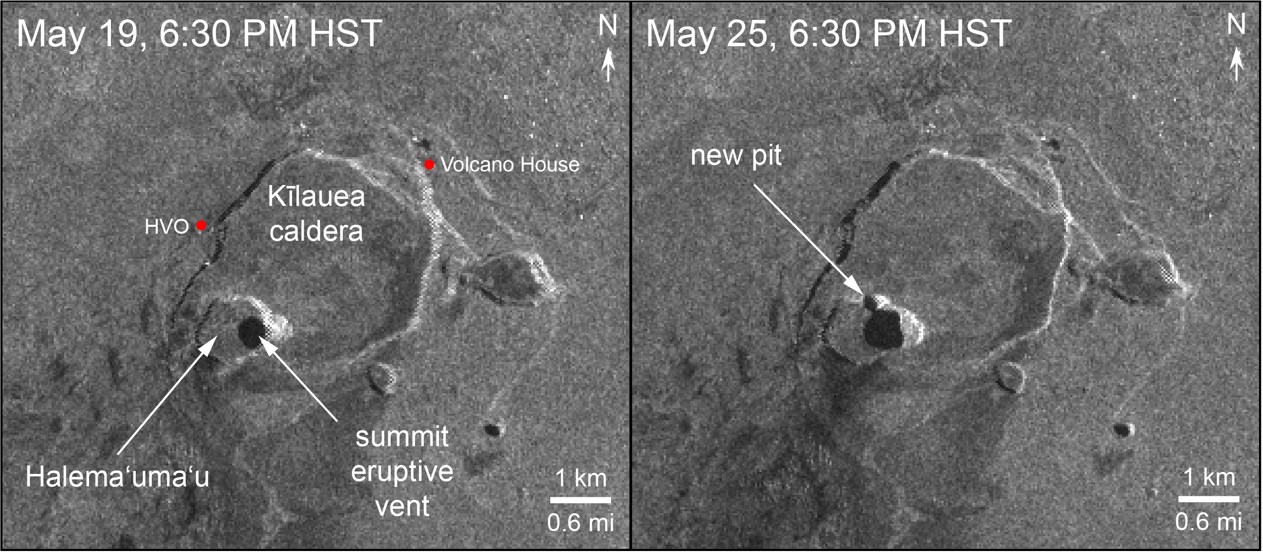
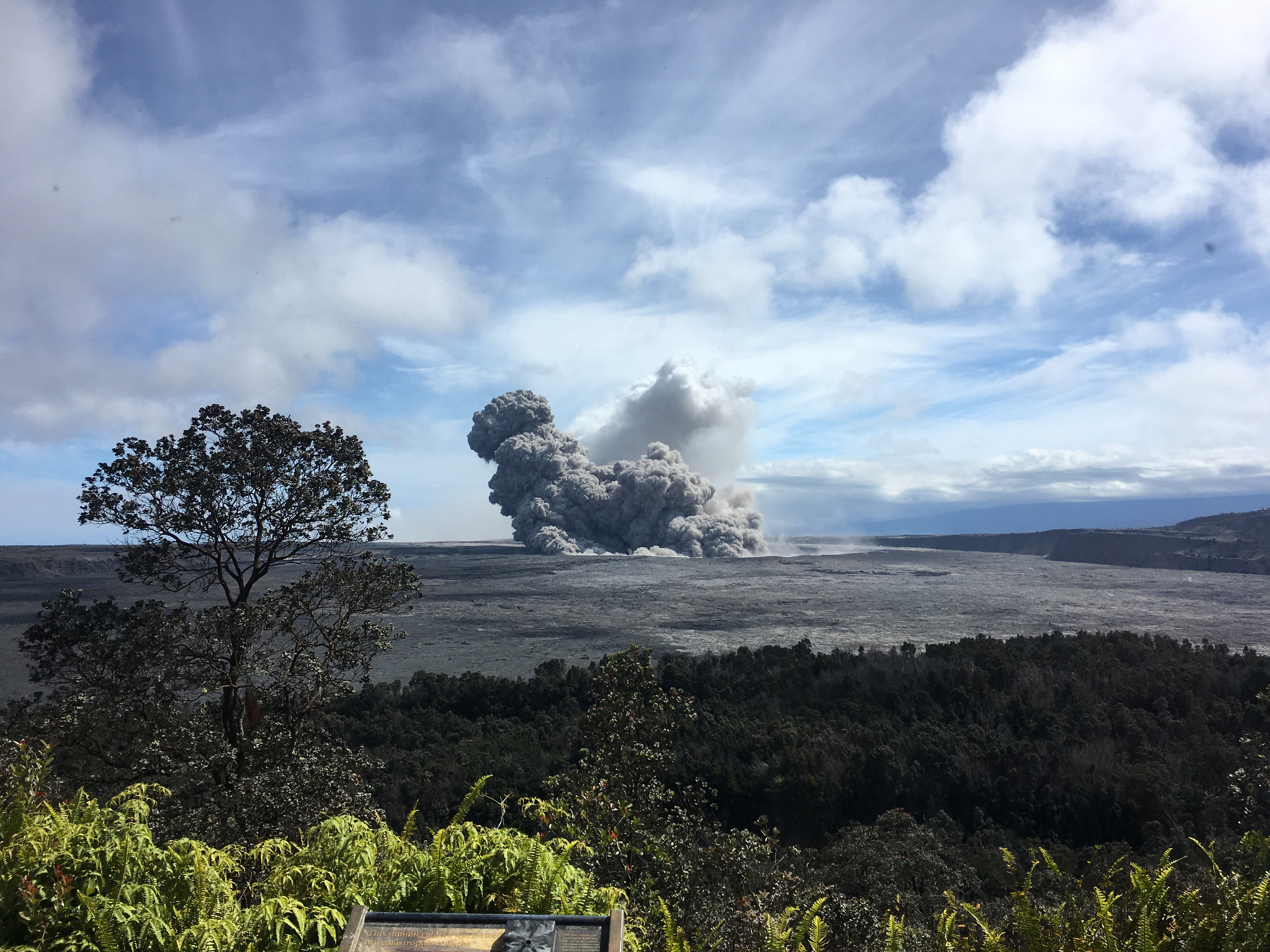
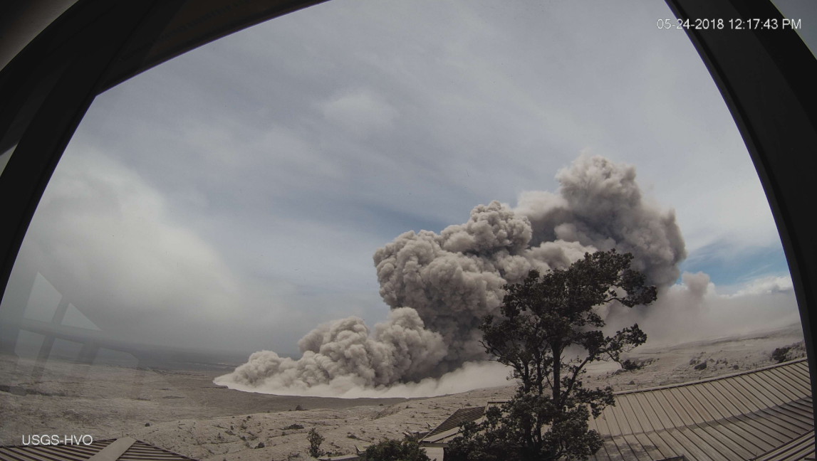
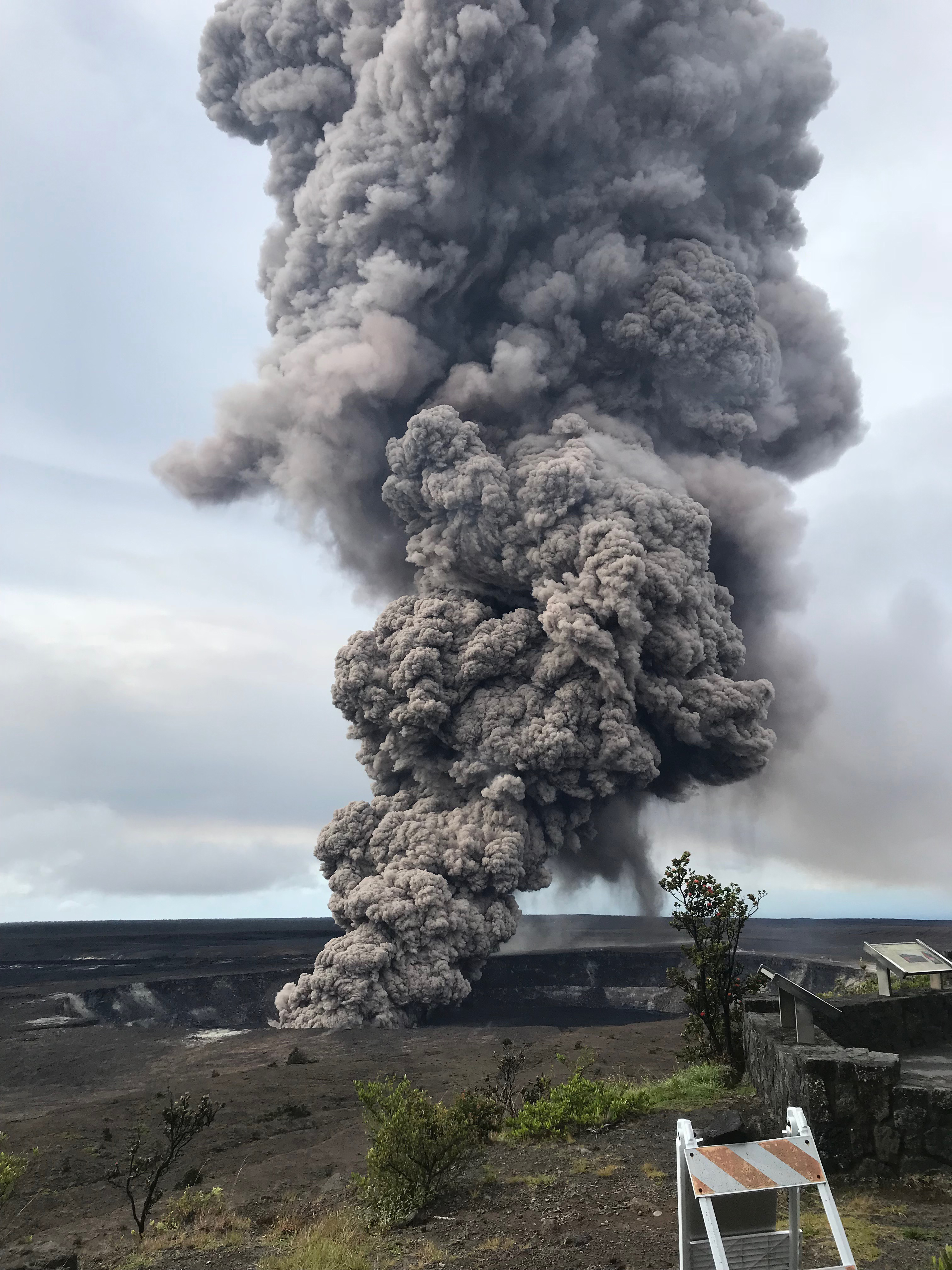
On Tuesday, 15 May, the volcano’s Halemaumau Crater commanded people’s attention by a display of towering ash plume from the crater that reached 12,000 feet high and could be seen for miles.
But this is not the explosion the USGS officials are warning people about since a week.


dark ash plume rising from Halemaumau Crater


According to KHON news Michelle Coombs, a geologist with the U.S. Geological Survey, told reporters on Tuesday, “It intensified today, but it wasn’t the big one, so to speak. Does that mean that we won’t see a much bigger, more explosive event? No, not necessarily. It could plug up, and we could yet in the future have the so-called ‘big one.’ Today was more of a gradual ramp-up, and it was continuous enough that we felt it was significant to put out a public warning.”

Coombs added that geologists were not sure what had caused the intensified ash emissions Tuesday.
But A temporary flight restriction for 12 nautical miles around Kilauea’s summit has been put in place.

Hawaiian Volcano Observatory issued a statement on Tuesday regarding rumors about a tsunami in the Pacific Ocean, “There is no geologic evidence for past catastrophic collapses of Kilauea Volcano that would lead to a major Pacific tsunami, and such an event is extremely unlikely in the future based on monitoring of surface deformation.”

A volcano is considered potentially active if it has erupted in the past 10,000 years. America has 169 active volcanoes, mainly clustered in the West — in Hawaii, Alaska, Wyoming, Washington, and California.

There are about 1,900 potentially active volcanoes around the world, with 500 having erupted since humans have been around, according to the USGS. Some of these volcanoes may never erupt, some may ooze lava slowly for years, and some may one day have a massive ejection that wreaks havoc. 
Respecting the Hawaiian legend of Pele- the goddess of fire, let’s take a more scientific look at how volcanoes are formed.

How Volcanoes are formed?


A Volcanos are formed when lava and molten rocks are squeezed in the surrounding area through a rift in the earth crust.  Volcanoes vary in shapes and sizes but they all share a few key characteristics. 

All volcanoes are connected to a reservoir of molten rock, called a magma chamber, below the surface of the Earth. When the pressure inside the chamber builds up, the buoyant magma travels out a surface vent or series of vents, through a central interior pipe or series of pipes. These eruptions, which vary in size, material, and explosiveness, create different types of volcanoes. 

The earth crust is made up of huge blocks called tectonic plates that slide on top of the mantle. Most volcanoes form at the boundaries of Earth’s tectonic plates.

The mantle is the mostly-solid bulk of Earth’s interior that lies between earth’s dense, super-heated core and its thin outer layer, the crust. The mantle accounts for a whopping 84% of Earth’s total volume is about 2,900 kilometers (1,802 miles) thick.

The temperature of the mantle ranges from 1000° Celsius (1832° Fahrenheit) near its border with the crust, to 3700° Celsius (6692° Fahrenheit) near its border with the core.


A majority of the volcanoes of the world are all clustered in the Ring of Fire, a horseshoe-shaped string of about 425 volcanoes that edges the Pacific Ocean. But, some volcanoes exist in the middle of the oceans, thousands of miles away from the tectonic plate boundaries.

Hot spots are intensely hot areas within the surface of the earth and tectonic activity above the hot spot cause them to erupt to create a volcanic mound. Over millions of years, volcanic mounds can grow until they reach sea level and create a volcanic island. Hawaiian islands are the best example of a volcanic island in the world.

As the years' pass, the hot spot stay put, but the movement of tectonic plate cause the islands to drift apart become extinct and eventually erodes back into the ocean.   

The Hawaiian Emperor seamount chain is a well-known example of a large seamount and island chain created by hot-spot volcanism. Each island or submerged seamount in the chain is successively older toward the northwest. Near Hawaii, the age progression from island to island can be used to calculate the motion of the Pacific Oceanic plate toward the northwest. The youngest seamount of the Hawaiian chain is Loihi, which presently is erupting from its summit at a depth of 1000 meters. Image courtesy of U.S. Geological Survey.

Experts think this volcanic chain of Hawaiian islands has been forming for at least 70 million years over a hot spot underneath the Pacific plate. Of all the inhabited Hawaiian Islands, Kauai is located farthest from the presumed hotspot and has the most eroded and oldest volcanic rocks, dated at 5.5 million years. Meanwhile, on the “Big Island” of Hawaii—still fueled by the hot spot—the oldest rocks are less than 0.7 million years old and volcanic activity continues to create new land. 

Hawaiian Volcanoes are all exclusively made up of lava called as a shield volcano, the other being the Stratovolcanoes which are steep and conical and rising up to several thousand meters above the landscape. 

Shield volcanoes are built almost exclusively of lava, which flows out in all directions during an eruption.

Shield volcanoes make up the entirety of the Hawaiian Islands. The Kilauea and Mauna Loa shield volcanoes, located on the “Big Island” of Hawaii, rise from the ocean floor more than 4,500 meters (15,000 feet) below sea level. The summit of Mauna Loa stands at 4,168 meters (13,677 feet) above sea level and more than 8,500 meters (28,000 feet) above the ocean floor, making it the world’s largest active volcano—and, by some accounts, the world’s tallest mountain.

The smaller volcano, Kilauea, has been erupting continuously since 1983, making it one of the world’s most active volcanoes. 

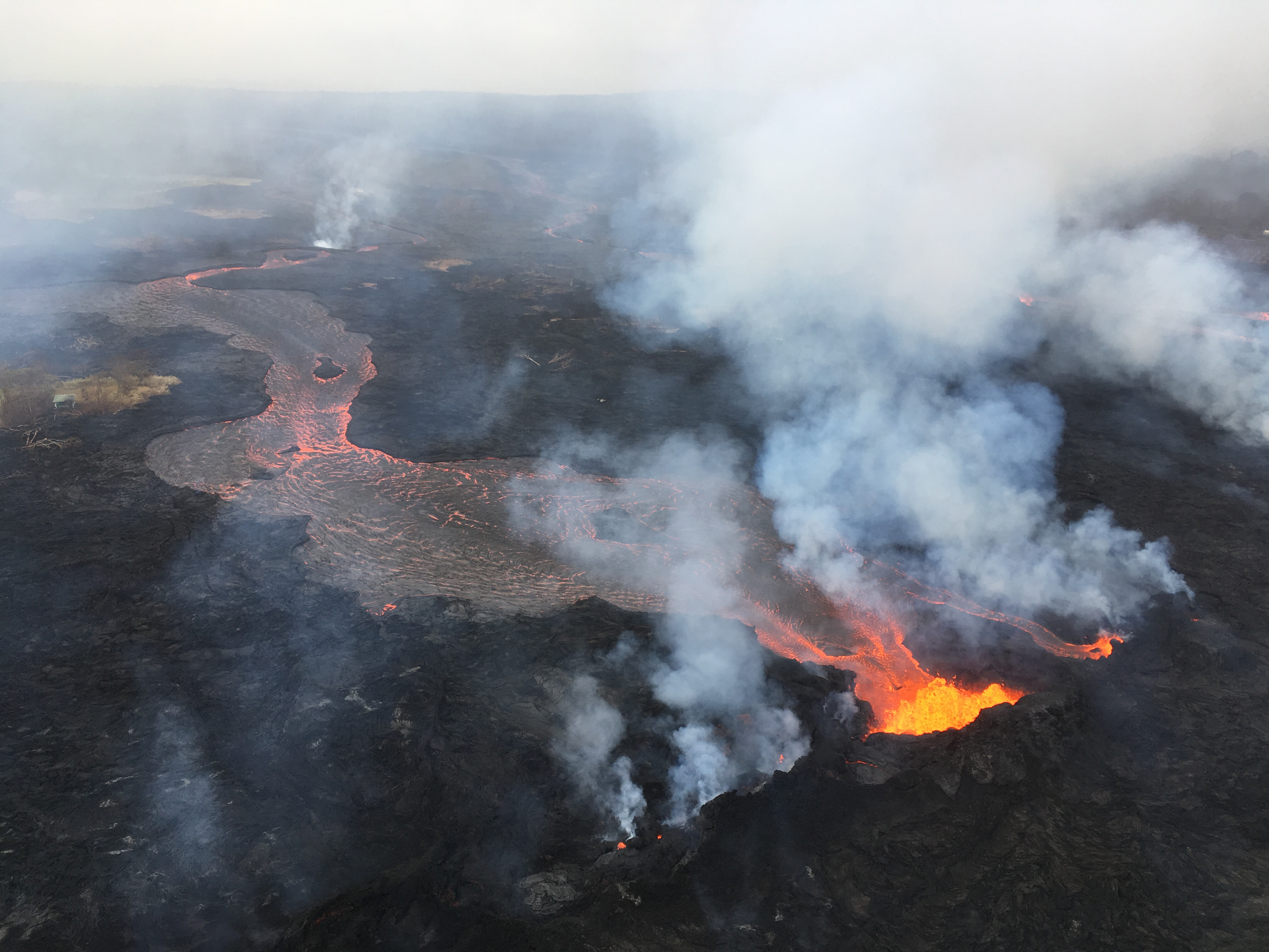
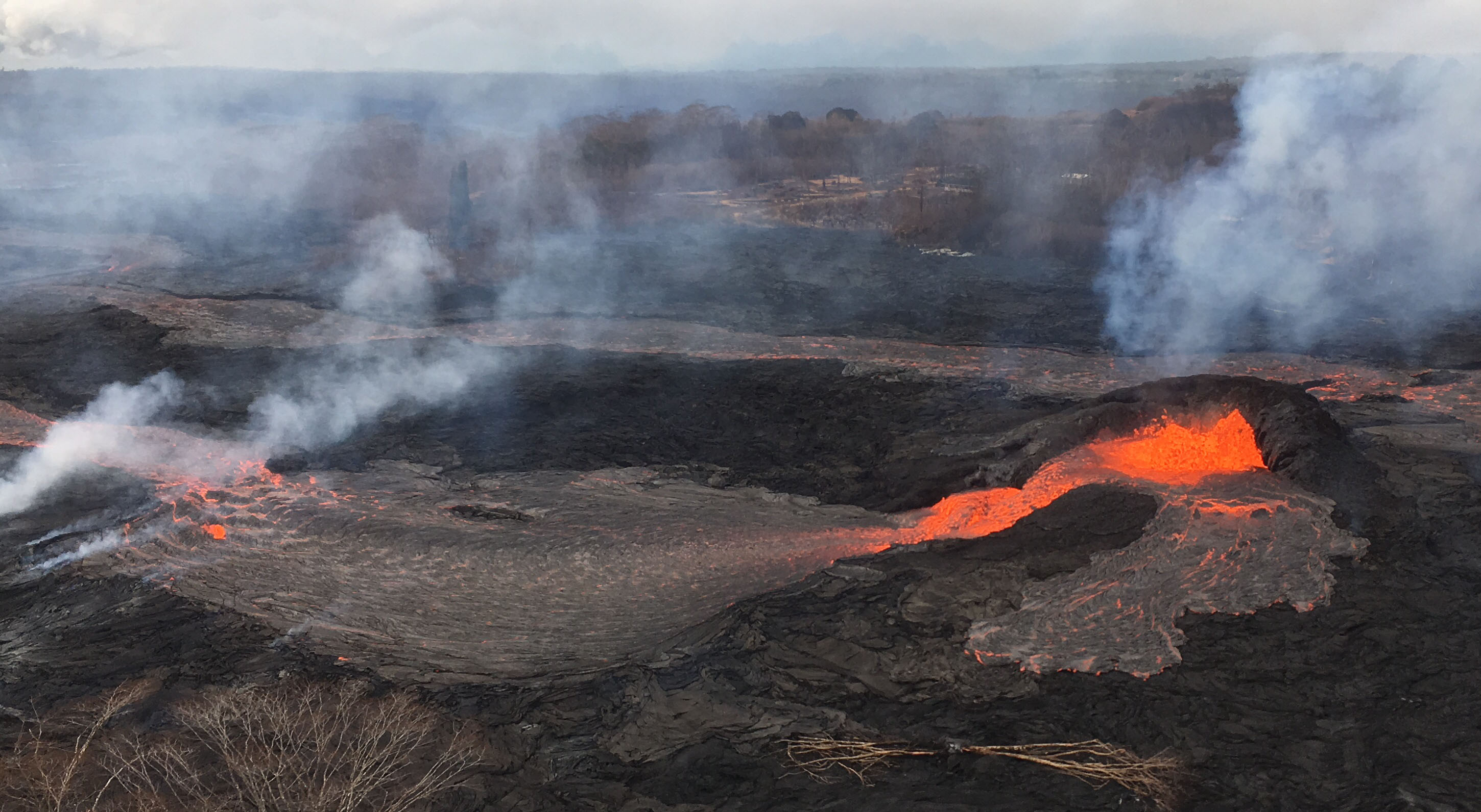
Hawaiian lava eruptions are calmest and known for their steady lava eruptions known as lava fountains or fire fountains. The highly fluid lava associated with Hawaiian eruptions flows easily away from the volcano summit, often creating fiery rivers and lakes of lava within depressions on the surrounding landscape.

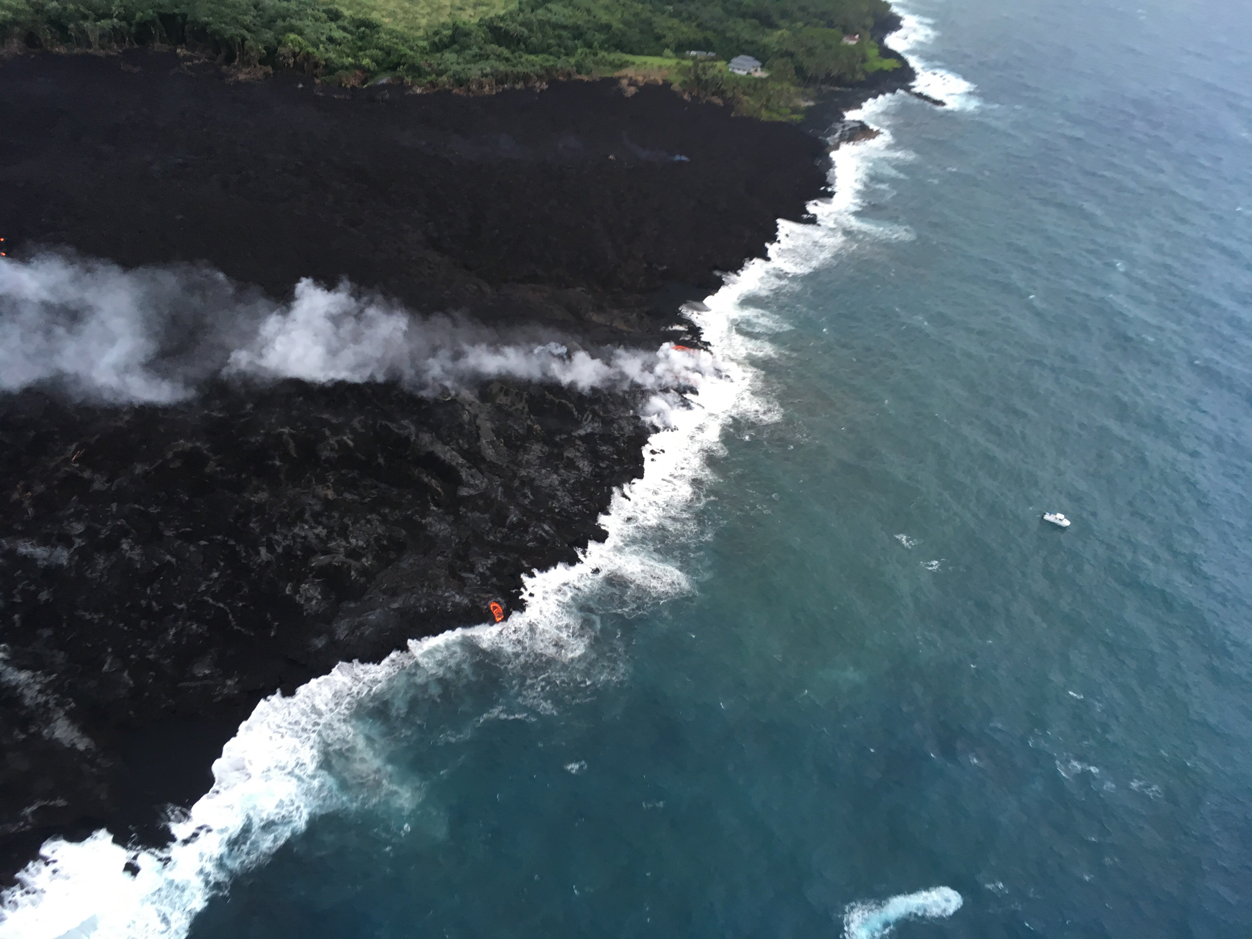
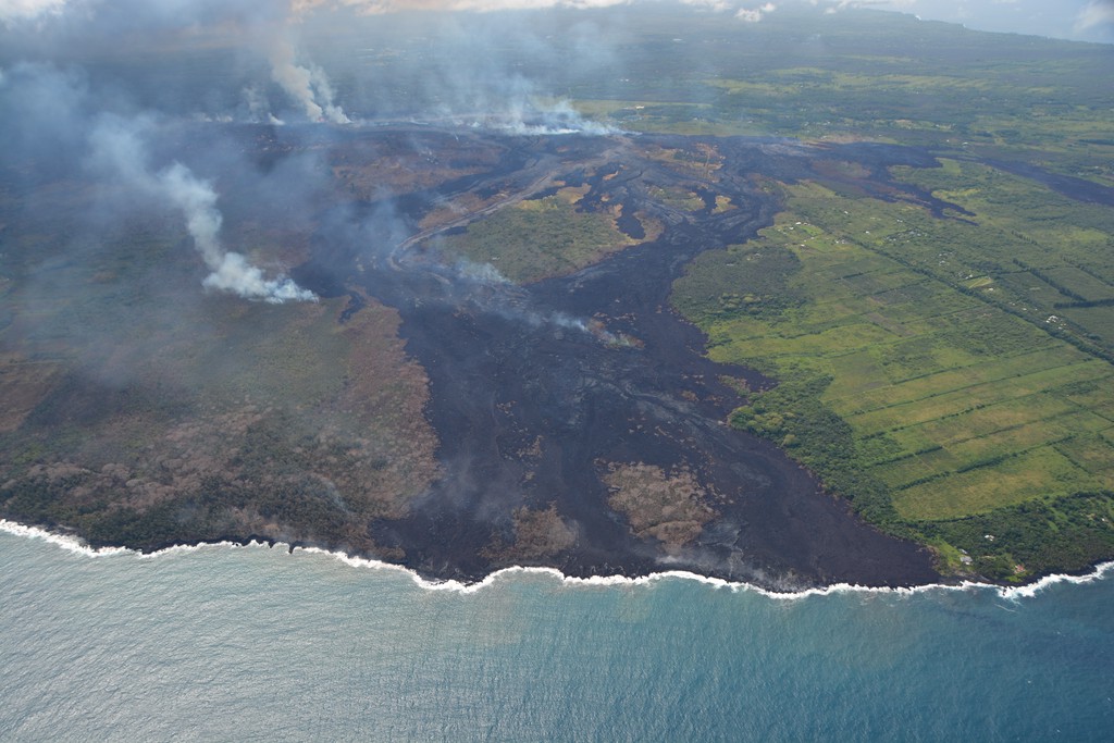
 Kilauea has produced lava flows covering more than 100 square kilometers (37 square miles) on the island of Hawaii. These flows continuously destroy houses and communities in their path, while also adding new coastline to the island.


Panoramic view of the lava at the end of the Chain of Craters Road, Hawaii Volcanoes National Park


History of Kilauea eruption


The Island of Hawai‘i with lava flows erupted in approximately the past 1,000 years shown in red. Located on the southeastern side, Kīlauea Volcano is 90% covered with young flows.

a 2004 Kilauea eruption, lava flowing into the sea 

The current ongoing eruption cycle began on Jan. 3, 1983, along the middle of the east rift zone. By April, the eruptions became localized at one vent. Lava fountains built a cinder and spatter cone 836 feet high (255 meters) that was named Pu`u `Ō`ō. 

The frequent short eruptions produced thick chunky lava flows that usually cooled and halted before reaching the coast. However, in July 1983, the lava made its inexorable advance into the nearby Royal Gardens subdivision and destroyed 16 homes. The expensive subdivision was largely abandoned.


Lava erupting from the PuʻʻŌʻō vent in June 1983

Previous to the 1983 eruptions, there were 2 more eruptions in 1955 and 1960. The eruption in 1955 lasted 88 days while the one in 1960 lasted 36 days.

Kilauea also erupted in 1986 and 1990. In 1986, lava flows cut through the town of Kalapana, on it’s way to the sea. As the lava field spread, cooled and spread again over the next three years it destroyed many homes and the Visitor Center in Hawai`i Volcanoes National Park. In March 1990, Kilauea entered its most destructive eruption period in modern history. Over the summer more than 100 homes, a church, and a store were buried beneath 50 to 80 feet (15 to 24 meters) of lava.


A stream of lava from Pu‘u ‘Ō‘ō flowing through the forest in the Royal Gardens subdivision, February 28, 2008. The lava stream is about 3 m (10 ft) wide. Kīlauea Volcano, Hawai‘i.
Sulfur dioxide emissions from the Halemaʻumaʻu vent in April 2008

In October 2012, Lava in Halema`uma`u crater overflowed the crater's ledge and lava reached the ocean in November when it flooded the ledge of the crater. Lava flowed over the ledge again in January 2013 and continues to flow into the ocean, according to USGS.

Volcanoes are some of Earth’s most potent natural hazards and agents of change. They release enormous amounts of energy and material, engaging natural processes that can modify landscapes at a local, regional, and even global scale.


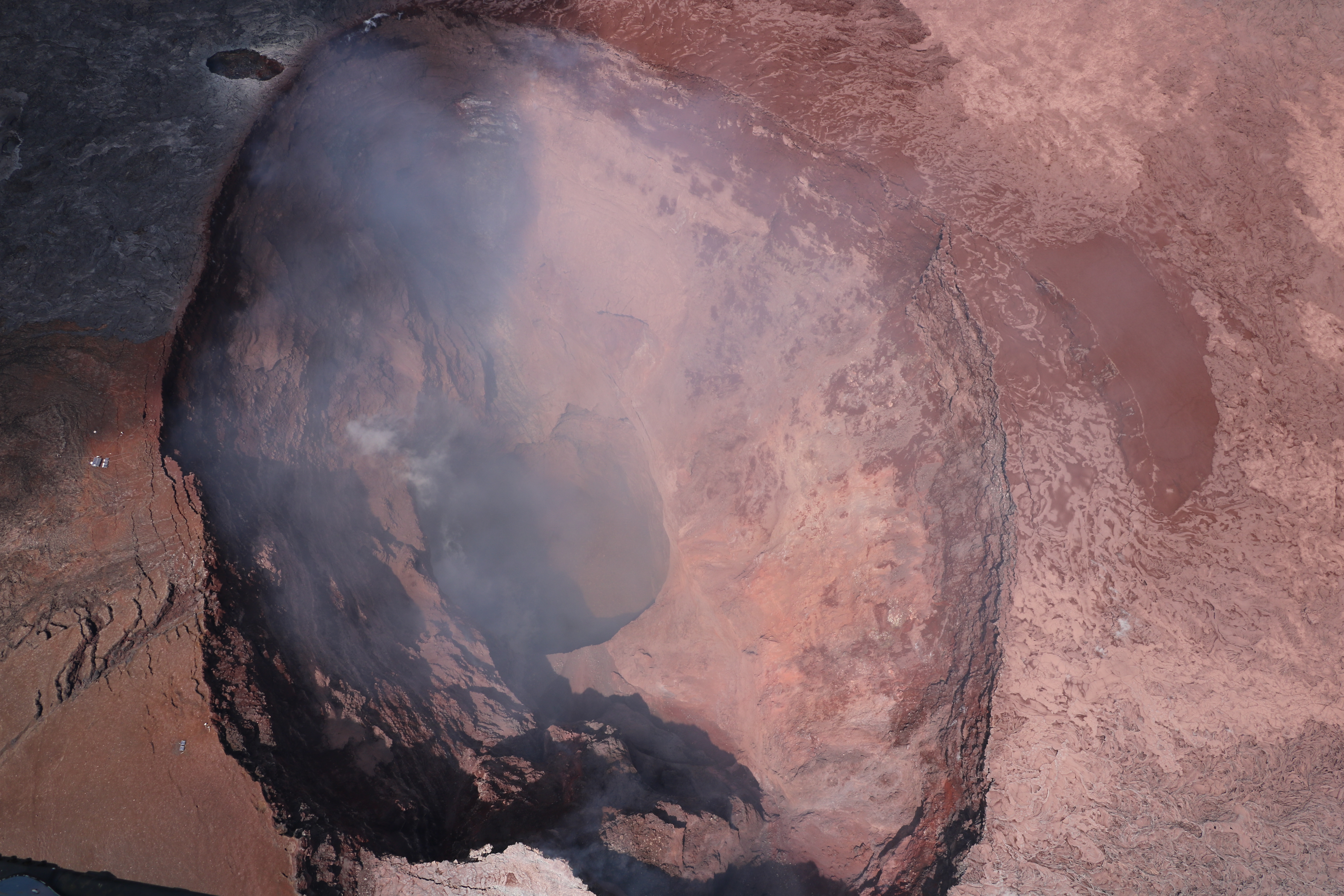
View upright from the Hawaiian Volcano Observatory overflight this morning at 8:25 a.m